
On paper, the Ramsey Cascades Trail in Great Smoky Mountains National Park sounds straightforward: an 8 mile out and back hike to the park’s tallest waterfall. In reality, loose rocks, wet stream crossings, and more than 2,000 feet of elevation gain turn this popular outing into a strenuous test that routinely surprises visitors who are used to smoother “national park style” paths.
Get the latest updates straight to your inbox!
Ramsey Cascades: A Classic Smokies Waterfall With a Sting in the Tail
Ramsey Cascades sits deep in the Greenbrier section of Great Smoky Mountains National Park, north of Gatlinburg, Tennessee. The only way to reach it is a 4 mile trail that climbs steadily along the Middle Prong of the Little Pigeon River and then the Ramsey Prong to a dramatic, multi tiered waterfall of roughly 100 to 105 feet, the tallest accessible by trail in the park according to the National Park Service and local guides.
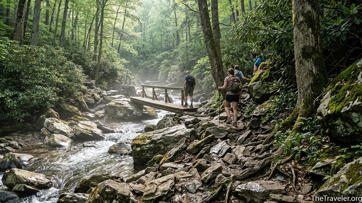
The route begins almost deceptively gently. From the small trailhead lot at the end of Ramsey Prong Road, the path follows an old gravel roadbed for more than a mile. Many families stroll this section in sneakers, lulled into thinking the whole hike will feel like a wide, rolling road walk with occasional views of the river. It is only after this early section ends that the character of the trail changes completely.
Beyond the old road, Ramsey Cascades turns into a narrow mountain path that gains close to 2,200 feet in total elevation from trailhead to falls. Underfoot, the surface becomes rooty and rock strewn, often slick from spray and seeps even on dry days. Stream crossings move from wide footbridges early on to narrow log bridges and rock hops, and the final half mile twists over boulders and wet rock slabs. For visitors arriving with a “moderate waterfall stroll” in mind, this shift can be jarring.
Part of the surprise comes from the trail’s popularity. It appears on visitor center wall maps and in many short online “best of the Smokies” lists alongside more forgiving hikes like Laurel Falls or Grotto Falls. First time visitors planning a long weekend in Gatlinburg routinely line up Ramsey Cascades for their first or second day, only to discover that it feels closer in effort to Mount LeConte’s steeper routes than to the family friendly waterfall walks near the Roaring Fork Motor Nature Trail.
How Loose Rocks Change the Difficulty Equation
Loose rock is one of the main reasons Ramsey Cascades feels harder than the stats suggest. After the roadbed ends, the trail tracks close to the Ramsey Prong and then climbs above it, often traversing short sections of broken, mobile stone. These are not uniform gravel but fist sized and larger rocks that roll underfoot when stepped on from the wrong angle, especially when hidden under wet leaves in spring and fall.
Even after a three year trail restoration project completed in late 2024, which added hundreds of rock steps and drainage features, hikers still report long stretches where you are effectively walking on uneven rock gardens rather than packed dirt. The new stone staircases are stable and welcome in the steepest spots, but between them the path often reverts to natural cobble that requires constant attention. For anyone used to the engineered tread of high traffic trails like Clingmans Dome or Alum Cave, the shift can feel like a different category of hike.
The practical effect is simple: every step demands more ankle strength and more focus, especially on the descent when tired legs meet gravity. A round trip that might take a reasonably fit hiker four hours on a smoother 8 mile path around Cades Cove often stretches to five or six hours here. Guides in Gatlinburg commonly tell guests to plan at least six hours car to car, factoring in slow going over rocks, snack breaks, and time at the falls.
On crowded weekends, loose rock sections become even more awkward. Passing or being passed means stepping off to the side into softer, less stable ground, or pausing on narrow outcrops of stone. It is common to see visitors in worn running shoes gingerly testing each foothold, which slows everyone behind them. A pair of light hiking shoes with good tread and a supportive heel cup can make the difference between feeling sure footed and feeling like you are skating marbles for several miles.
Water, Footlogs and Stream Crossings That Catch Hikers Off Guard
Water is the second ingredient that makes Ramsey Cascades harder than many expect. For much of the trail, the Ramsey Prong and other small streams run either beside the path or directly across it. Early in the hike, a long footbridge crosses the Middle Prong of the Little Pigeon River, offering a dramatic view of white water pouring over boulders. As you climb higher, the bridges become narrower “footlogs” and the crossings less straightforward.
The National Park Service notes several log bridges with handrails as well as unbridged stream crossings. After heavy rain or during spring snowmelt, rocks that serve as stepping stones can sit just below the surface. Even during a typical June visit, hikers frequently report getting at least one foot wet unless they are very careful or use trekking poles for balance. Wet rock covered in algae becomes slick, especially in shaded spots where sun never fully dries the stone.
For many visitors, the mental demand of these crossings is as taxing as the physical side. Parents carrying children in hiking carriers must navigate narrow logs above moving water. Visitors with a fear of heights or poor balance sometimes freeze midway and need coaching from friends to finish a crossing. On busy Saturdays, small backups form at the trickiest footlogs as each person in line takes their turn, gripping the handrail and shuffling step by step across.
Real world examples highlight the impact. Local outfitters in Gatlinburg regularly field late afternoon calls from guests who turned around at one of the higher crossings because the water felt too swift after a night of thunderstorms. Park rangers have responded to twisted ankles and minor falls caused more by slipping from wet rocks into shallow water than from dramatic cliff drops. None of this makes Ramsey Cascades dangerous for prepared hikers in typical conditions, but it does explain why the trail’s “difficult” rating is more than a formality.
Steep Elevation Gain That Builds Slowly, Then Bites Hard
Elevation is the third factor that transforms Ramsey Cascades into a demanding outing. The trail gains just over 2,000 feet from the trailhead to the base of the falls, and almost all of that gain occurs in the last three miles. Early on, the grade feels gentle enough that people chat easily while walking. By the time the path narrows and begins climbing above the creek, conversations thin out and hikers begin to take more frequent breathers at convenient boulders and log benches.
The most punishing stretch comes in the final mile, where clusters of rock steps, short switchbacks, and rooty pulls stack together with almost no truly flat relief. The restored trail has added more than 600 stone steps to control erosion, but each of those steps is an actual rise in elevation your legs must conquer. On hot summer days, visitors commonly underestimate how much these sustained climbs will tax them, particularly those who live at sea level and are not acclimatized to hiking for hours in humid Appalachian air.
Compared with other Smokies routes, Ramsey Cascades compresses the effort into a shorter distance. Charlies Bunion from Newfound Gap involves a comparable elevation gain but spreads it over roughly 8 miles one way on the Appalachian Trail, with long contouring sections that allow for recovery. Alum Cave to Mount LeConte gains similar vertical but offers more varied terrain and frequent viewpoints that naturally break up the work. Ramsey, by contrast, feels like an increasingly steep tunnel of forest and creek until the falls suddenly appear.
Downhill, that same elevation becomes a joint pounding challenge. The rock steps that feel sturdy and reassuring on the way up become large drops for tired knees on the way down. Visitors in their 50s and 60s, as well as younger hikers with past knee or ankle issues, often describe the descent as the hardest part. Hiking poles can make a dramatic difference here, transferring some of the load from knees to arms and providing extra stability when planting feet on uneven rocks.
Trail Restoration Has Helped, But Not Softened the Wild Feel
In November 2024, the National Park Service announced the completion of a three year Trails Forever rehabilitation of Ramsey Cascades. Crews, supported by the nonprofit Friends of the Smokies, installed new log bridges, rebuilt rock walls and steps, and added hundreds of drainage features to shed water off the trail and slow erosion. Helicopters ferried in heavy materials that mules could not reasonably carry.
The result, according to both rangers and recent trip reports, is a more durable path that holds its shape during storms and a safer experience at historically troublesome spots. Washouts that once demanded awkward detours around tilted trail tread have been filled and armored. Handrails on certain bridges have been replaced or reinforced, and brush has been cleared back from the corridor so hikers are less likely to be slapped in the face by wet rhododendron branches as they pass.
What the work has not done is turn Ramsey Cascades into a manicured, parkway style stroll. Many of the new features are designed to look natural, blending stone steps into existing rock outcrops and using native timber for bridges. The underlying character remains that of a rugged mountain path following a living river. Erosion features will still form between stone structures during heavy rain, rocks will still become slick from the constant spray and seepage that support lush moss, and wind or ice storms will occasionally topple trees across the trail until sawyer crews can clear them.
For travelers, this means you can trust the basic integrity of the route more than in past years, but you should not downgrade your expectations of difficulty. The official park description still labels the hike as strenuous, and local lodging websites that briefly called it “moderate” in older marketing copy have largely updated their language to warn guests that this is a demanding all day excursion suitable for reasonably fit, prepared hikers.
Planning Your Day: Time, Gear and Seasonal Surprises
Because Ramsey Cascades demands more from hikers than many Smokies waterfall trails, planning matters. Most visitors staying in Gatlinburg or Pigeon Forge underestimate the driving time just to reach the trailhead. From downtown Gatlinburg, it typically takes 35 to 45 minutes in normal traffic to wind along U.S. 321, turn into the Greenbrier entrance, and follow the narrow, partly gravel Ramsey Prong Road to its end. Parking is limited to a small lot and roadside pull offs; on peak season Saturdays in June and October, it often fills by mid morning.
On the trail, a fit hiker with good footing can complete the 8 mile round trip in about 4.5 to 5 hours of moving time. Add a leisurely lunch at the falls, photo breaks, and slower going at stream crossings, and many parties find the outing takes 6 to 7 hours car to car. Families with school age children or groups that include someone recovering from injury routinely spend more than 8 hours on the hike, particularly if the rivers are running high. Starting before 9 a.m. and carrying headlamps or small flashlights is a wise hedge against underestimating the day.
Gear for Ramsey Cascades does not need to be technical, but it does need to be thoughtful. Trail runners or hiking shoes with sticky rubber outsoles perform far better on wet rock than worn casual sneakers. Lightweight trekking poles add balance at water crossings and on steep downhills. Many locals carry a small daypack with at least 2 liters of water per person, snacks with a mix of salt and carbohydrates, a compact rain jacket, and a simple first aid kit. Because cell service in Greenbrier is unreliable, a downloaded offline map from a service like Gaia GPS or the NPS app can help you track progress and avoid anxiety about how much climbing remains.
Season also shapes the experience. In early spring, snowmelt and frequent rain swell the Ramsey Prong, making crossings more challenging but the waterfall itself even more impressive. Summer brings lush green canopy and shaded relief from the Tennessee heat, but also high humidity and afternoon thunderstorms. Autumn adds brilliant foliage at the cost of leaves that can hide holes and slick roots. Winter, when the road is open and conditions are safe, can deliver dramatic ice formations around the falls, but ice on rocks and bridges can make the trail treacherous for anyone without traction devices.
Who Should Attempt Ramsey Cascades, and Who Is Better Off Skipping It
Given the combination of loose rocks, water crossings, and elevation, Ramsey Cascades is best suited for hikers who already have a few all day routes under their belt. If you are comfortable with trails like Alum Cave to Inspiration Point, Rainbow Falls, or Chimney Tops and are looking for a bigger challenge with fewer crowds, Ramsey is a natural next step. The reward is not only the waterfall itself, but also long stretches of old growth forest with towering tulip poplars and hemlocks that escaped the logging that shaped so much of the Smokies before it became a national park.
Families with adventurous older children often enjoy the trail if everyone understands what lies ahead. In practical terms, that means kids who can hike 8 to 10 miles elsewhere without major complaint and who listen to instructions at stream crossings and near slippery rock edges. Local guiding services in Gatlinburg report bringing groups of teenagers on the trail with great success, using the hike as an introduction to pacing, hydration, and Leave No Trace principles.
On the other hand, travelers with limited time in the Smokies, new hikers, or visitors with balance or joint issues may be happier choosing alternative waterfall routes. Laurel Falls offers an easy paved path to a picturesque cascade close to the main park road, though it is often extremely crowded. Grotto Falls, reached from the Roaring Fork Motor Nature Trail, involves a moderate 2.6 mile round trip with some roots and rocks but none of the serious elevation or commitment of Ramsey Cascades. Porters Creek in the same Greenbrier area delivers wildflower rich streamside scenery on a mostly gentle path, and many locals recommend it as a “Ramsey lite” for those not ready for the full challenge.
Importantly, there is no shame in turning around early on Ramsey Cascades. The hike offers views of boulder strewn streams and rich forest long before the final waterfall. If your group reaches the halfway point and is already flagging, choosing to enjoy lunch by the river and retrace your steps is a smart decision, not a failure. Rangers in the park routinely emphasize that most incidents occur to people who push beyond their comfort zone because they feel locked into “making it to the end” at all costs.
The Takeaway
Ramsey Cascades has earned its reputation as one of the Great Smoky Mountains’ signature waterfall hikes, and in recent years its rebuilt bridges, steps, and drains have only increased its appeal. At the same time, the trail remains far from tame. Loose rocks demand attention on every step, stream crossings fluctuate with the weather, and sustained elevation gain turns what looks like a mid length outing on paper into a full day endeavor for many visitors.
For travelers planning a trip to Gatlinburg or Pigeon Forge, understanding these realities is the key to enjoying Ramsey Cascades rather than enduring it. Arriving early, bringing appropriate footwear and poles, respecting seasonal conditions, and giving yourself plenty of time can turn a potentially grueling surprise into a memorable highlight of your visit. If that level of effort does not match your goals, the park offers dozens of other trails that showcase waterfalls, rivers, and forest without the same level of commitment.
Ultimately, Ramsey Cascades rewards those who arrive prepared. The roar of water tumbling more than 100 feet over mossy ledges, framed by old growth trees and enveloped in cool spray, feels all the sweeter when you know you earned it step by careful step. For many hikers, that sense of having truly worked for the view is exactly what makes this deceptively hard trail worth seeking out.
FAQ
Q1. How long does it take to hike Ramsey Cascades round trip?
Most reasonably fit hikers should plan 6 to 7 hours car to car, including driving the narrow access road, taking breaks, and spending time at the waterfall.
Q2. How difficult is the Ramsey Cascades Trail compared with other Smokies hikes?
The trail is rated strenuous and feels significantly harder than shorter waterfall walks like Laurel Falls or Grotto Falls, roughly comparable in effort to some Mount LeConte routes.
Q3. Is Ramsey Cascades safe for children?
It can be appropriate for experienced young hikers who can handle 8 miles, steep climbs, and stream crossings, but it is not ideal for very young kids or toddlers.
Q4. Do I need special footwear for this hike?
Sturdy hiking shoes or trail runners with good tread are strongly recommended because of loose rocks, wet sections, and steep stone steps, especially on the way down.
Q5. Are trekking poles useful on Ramsey Cascades?
Yes, poles help with balance on narrow log bridges, slippery rocks, and steep descents, and many local guides and experienced hikers use them on this trail.
Q6. When is the best time of year to hike to Ramsey Cascades?
Late spring and early summer offer strong water flow and lush greenery, while autumn brings vivid foliage; winter and early spring can be icy or have high water.
Q7. Can I swim at the base of Ramsey Cascades?
Wading is strongly discouraged and climbing on rocks near the base is considered dangerous, as wet, sloping stone and strong currents have led to serious accidents in the past.
Q8. Is parking at the Ramsey Cascades trailhead limited?
Yes, parking consists of a small lot and short stretches of roadside pull offs, so arriving early in the morning is the best strategy, especially on weekends and holidays.
Q9. Is the trail open every day now that restoration work is complete?
As of 2025, the National Park Service reports the trail open seven days a week, though temporary closures can still occur after storms or for maintenance.
Q10. Are there easier nearby alternatives if Ramsey Cascades feels too hard?
Yes, Porters Creek in the same Greenbrier area and Grotto Falls near Roaring Fork offer scenic streamside hiking and waterfalls with much less elevation and technical terrain.