
Ramsey Cascades is one of the most rewarding waterfall hikes in Great Smoky Mountains National Park, but it is also among the most demanding. Before you commit to this full-day outing, it pays to understand the trail’s difficulty, current access issues, and the real on-the-ground conditions you are likely to encounter. This guide gathers the latest information and practical details to help you decide if the Ramsey Cascades Trail is right for you and how to tackle it safely and responsibly.
Get the latest updates straight to your inbox!
Where the Ramsey Cascades Trail Is and Why It Matters
The Ramsey Cascades Trail sits in the Greenbrier area on the Tennessee side of Great Smoky Mountains National Park, east of Gatlinburg. The hike follows Ramsey Prong up a steep, rugged valley to the tallest waterfall accessible by trail in the park. For many hikers who have already visited Laurel Falls or Abrams Falls, Ramsey Cascades feels like a deeper step into the backcountry, with far fewer crowds and a wilder atmosphere.
The waterfall itself drops roughly 100 feet in a series of beautiful rock steps into a boulder-filled pool, framed by mossy stones and dense forest. Even on busy spring weekends, it feels more remote than the park’s roadside attractions. That remoteness comes with trade-offs: the drive in is longer, the road is narrower, and rescue responses take time if something goes wrong. Travelers staying in Gatlinburg or Pigeon Forge often plan this as their “big hike” of the trip, saving an entire day for it rather than trying to squeeze it between other activities.
Because the trail passes through some of the largest remaining tracts of old-growth forest in the Smokies, it is popular with nature-focused travelers and photographers. You are walking among towering tulip poplars, yellow birch, and eastern hemlocks, some wider than a compact car. For visitors who have only seen younger second-growth forests elsewhere in the Appalachians, Ramsey Cascades offers a rare chance to experience what the region’s woodlands looked like before extensive logging.
It is also important to understand that access to the Greenbrier area, and specifically to Ramsey Prong Road and the trailhead, has been affected by flood damage, ongoing repairs, and occasional wildlife-related closures in recent years. Conditions can change from one season to the next, so checking the National Park Service’s current road and trail updates shortly before your trip is essential.
Trail Stats, Difficulty, and Who Should Attempt It
The Ramsey Cascades Trail is approximately 8 miles round trip, out and back, with more than 2,000 feet of elevation gain. On paper, that may not sound extreme, but the combination of steady climbing, rugged footing, and humidity typical of the Smokies makes it feel harder than many hikers expect. For a reasonably fit adult, the hike commonly takes between 5 and 7 hours total, including time at the falls.
The first section follows an old gravel road and feels relatively gentle. After about 1.5 miles the trail narrows and becomes much more technical, climbing over roots, rocks, wet stone steps, and a few short but steep pitches. In the final mile, you will be picking your way over boulders and uneven rock slabs, often with slick, mossy surfaces, especially after rain. This is not a hike to attempt in flip-flops or casual sneakers picked up at a Gatlinburg outlet; sturdy hiking shoes or boots with real traction make a noticeable difference.
Because of the elevation gain and rough footing, the trail is generally considered strenuous. It is not ideal for very young children, travelers with significant knee or ankle problems, or anyone unused to several hours of continuous hiking. Families who want a waterfall experience with less commitment often opt for Grotto Falls or the shorter walk to Cataract Falls near Sugarlands Visitor Center instead, while leaving Ramsey Cascades for a future visit when children are older or adults have a bit more trail experience.
Realistically assess your pace. If you typically cover 2 miles per hour on level ground, expect closer to 1 to 1.5 miles per hour on the upper half of this trail. Travelers staying in cabins in the Greenbrier or Pittman Center area sometimes schedule this hike for a cool weekday morning, then book something low-key for the evening, like a casual dinner in downtown Gatlinburg rather than a late-night show in Pigeon Forge.
Access, Parking, and Current Conditions
Access to Ramsey Cascades starts from the Greenbrier entrance on US 321, roughly 5 to 6 miles east of central Gatlinburg. From there a park road follows the Middle Prong of the Little Pigeon River before branching onto Ramsey Prong Road toward the trailhead. This last stretch is narrower, with gravel or broken pavement in places, and can feel tight for larger rental SUVs. Low-slung sports cars or heavily loaded RVs are not recommended beyond the main picnic and ranger station area.
In recent years, heavy rainfall and flooding have damaged parts of Greenbrier Road and Ramsey Prong Road, including culverts and sections leading to the Ramsey Cascades trailhead. The National Park Service has intermittently closed the road and trail for repairs and, at times, for bear activity in the area. Because of this, the single most important logistical step is to verify current road and trail status on the official Great Smoky Mountains National Park alerts and conditions page within a day or two of your planned hike. Seasonal closures have sometimes affected access from February through early spring, while short-term closures can follow major storms.
Parking at the actual trailhead is limited, with a small lot and some roadside pull-offs. On busy spring and fall weekends, it can fill by mid-morning. Travelers who want a stress-free start often aim to arrive between 7:30 and 8:30 a.m., especially on Saturdays. If you arrive later and find the lot full, parking farther down the road will add extra distance and a road walk to your day. Arriving early also gives you more flexibility if you encounter slower-than-expected pace or need extra breaks on the upper trail.
Cell service is spotty to nonexistent in Greenbrier. Do not rely on navigation apps or ride-hailing services once you leave Gatlinburg. Many hikers download offline maps to their phones in advance using common apps or simply purchase a printed Great Smoky Mountains trail map at Sugarlands Visitor Center, the NOC store in Gatlinburg, or outdoor retailers in town. A simple paper map can be invaluable if you miss a turn driving or need to reassess plans because of a closure.
What to Expect on the Trail, Step by Step
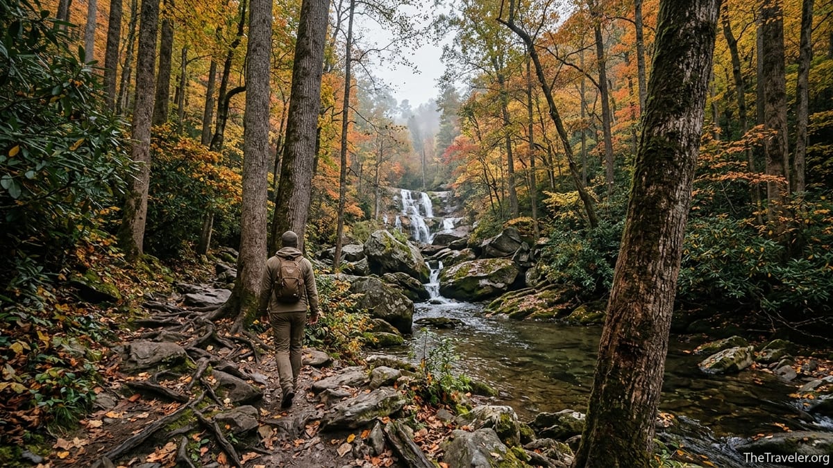
From the trailhead, you will begin on a wide, gently rising path that follows an old road bed along Ramsey Prong. The sound of the creek is constant, and you will pass by large boulders, rhododendron thickets, and occasional side streams. In this lower section, many visitors underestimate the hike, lulled by the comfortable grade and broad tread. This is a good place to adjust packs, remove or add layers, and find a sustainable pace before the real climb begins.
After roughly 1.5 miles, the character of the hike changes as the trail narrows and the forest closes in. You enter one of the park’s significant tracts of old-growth forest, where tulip poplars tower above and the understory grows denser and cooler. Here the tread underfoot shifts to a mix of roots, embedded rocks, and short rocky steps. You may encounter several footlogs or small bridges over creeks, some of which have been rebuilt or rerouted after recent floods. In wet conditions, these structures and nearby rocks can be slick, so many hikers slow down significantly in this section.
The final mile is the steepest and most rugged. The trail climbs among large boulders, hugging the hillside with drops down to the creek in places. You may need to use hands occasionally for balance, stepping up and down over irregular rock ledges. After rain, thin sheets of water can run across rock slabs, and patches of mud linger in shaded spots. In early spring or late fall, coated roots and stones can hold frost or ice into the late morning, adding another layer of caution. This is part of why many hikers aim for dry weather and shoulder-season temperatures, rather than attempting the trail during a cold snap.
Eventually, the trail emerges at the base of Ramsey Cascades, where the creek tumbles down multiple tiers of rock into a shallow pool. There are large boulders scattered around that make natural seating, and many hikers choose one for a snack or lunch break, snapping photos and cooling off before the return trip. Visitors should heed posted warnings and common sense: do not climb the rocks near or behind the waterfall, and avoid wading in swift or high water. The wet stone around the cascades has been the site of serious and occasionally fatal accidents when visitors tried to scramble higher or pose for dramatic photographs.
Seasonal Timing, Weather, and Wildlife
Ramsey Cascades can be hiked in all four seasons, but conditions vary greatly. Spring brings high, dramatic flows and blooming wildflowers along the lower trail, including trillium and violets, but also frequent rain and slick footing. Summer offers long daylight and lush green foliage, yet humidity can be intense, and late-afternoon thunderstorms are common. Many summer hikers aim for early starts to reach the falls and be on their way down before storms typically build.
Autumn is arguably the most popular time, with colorful foliage and cooler temperatures. The old-growth trees around the trail display a mix of gold, orange, and deep red, especially from late October into early November in typical years. Weekends during peak color can be busy, especially when combined with fall events in Gatlinburg and Pigeon Forge, so lodging prices tend to rise accordingly. Travelers staying at cabins or lodges in Pittman Center or outside Cosby sometimes find slightly better value compared to central Gatlinburg during these peak weeks.
Winter hiking at Ramsey Cascades is possible but should be approached cautiously. Ice can form on rocks and footlogs, and snow can obscure roots and depressions. On particularly cold days, parts of the waterfall itself can freeze into striking formations, but reaching it may require microspikes and experience with winter conditions. Some years see sections of the Greenbrier road closed for weather or maintenance, further complicating access.
Wildlife encounters are another key consideration. Black bears are common in the Smokies, and Greenbrier is no exception. There have been periods when the National Park Service temporarily closed the Ramsey Cascades Trail and Ramsey Prong Road due to bear activity. Hikers should carry bear spray if they are comfortable using it, store food securely, make noise in dense vegetation, and maintain distance if they see a bear. Smaller wildlife such as snakes, salamanders, and insects are also part of the experience. In warmer months, ticks and mosquitoes are present, so using repellent, wearing long socks, and doing a quick tick check after the hike is prudent.
Gear, Safety, and Practical Planning Tips
Although Ramsey Cascades is not a technical climb, treating it like a serious backcountry day hike is the safest approach. At a minimum, plan to carry 2 to 3 liters of water per person, especially in warm months. Many hikers use a combination of refillable bottles and a hydration reservoir. Sports drinks or electrolyte mixes can help replace what you lose through constant climbing in humid air. There are plenty of creeks along the route, but water should be treated with a filter, UV purifier, or chemical tablets before drinking.
Footwear matters. Trail runners with grippy soles or midweight hiking boots from recognizable outdoor brands are commonly seen on this trail. Budget sneakers with worn tread are a frequent cause of slips, particularly on the polished rock steps and boulders near the falls. Trekking poles can be very helpful, especially on the descent when knees are tired and the risk of missteps increases. Even a simple pair of aluminum poles bought at an outfitter in Gatlinburg can pay for themselves in reduced fatigue and improved balance.
Packing a light but complete day-hiking kit is advisable. That usually includes a small backpack, rain jacket or poncho, insulating layer in cooler months, basic first-aid supplies, a headlamp or small flashlight in case the hike takes longer than planned, snacks with real calories, and a paper map or downloaded offline map. Some travelers also bring a sit pad or lightweight towel for the rocks at the falls, plus a dry bag or plastic pouch to keep phones and cameras safe from spray.
From a safety perspective, avoid starting late in the afternoon, let someone know your plans, and do not push past your limits just to “finish the trail.” Turning around before the falls is still a worthwhile forest hike. Visitors who are unsure about tackling Ramsey Cascades on their own sometimes hire a local guide service based in Gatlinburg or Pigeon Forge. While that is an extra expense, it can be reassuring for those new to mountain hiking, and guides often know current trail conditions and alternative routes if access changes suddenly.
The Takeaway
The Ramsey Cascades Trail offers a combination of old-growth forest, rushing water, and a dramatic multi-tiered waterfall that is hard to match elsewhere in Great Smoky Mountains National Park. It is a destination that rewards preparation, patience, and respect for mountain conditions. Travelers who approach it as a serious day hike, rather than a casual stroll, are far more likely to enjoy the day and return safely.
Before you go, confirm road and trail status, plan an early start, and pack as if you might be out longer than expected. Choose footwear and clothing that match a steep, potentially slippery route, and stay conservative around fast-moving water and wet rock. If you find that the distance or difficulty is more than you are ready for on this trip, remember that the Smokies are full of other hikes, from short family-friendly waterfall walks to moderate ridge trails with wide views.
Whether you ultimately stand at the base of Ramsey Cascades or simply explore the lower reaches of Greenbrier, you will gain a deeper sense of the Smokies’ rugged terrain and living forests. For many repeat visitors, this trail becomes a benchmark hike, something they look back on when planning future adventures in the park. With careful planning and realistic expectations, it can be a highlight of your time in the Great Smoky Mountains.
FAQ
Q1. How long is the Ramsey Cascades Trail and how much time should I plan?
The hike is about 8 miles round trip with more than 2,000 feet of elevation gain. Most hikers should plan 5 to 7 hours total, including breaks at the waterfall.
Q2. Is the Ramsey Cascades Trail currently open?
Access has varied due to road work, flood damage, and bear activity in recent years. Always check the latest Great Smoky Mountains National Park road and trail conditions shortly before your visit to confirm whether Ramsey Prong Road and the trail are open.
Q3. Is this hike suitable for children or beginners?
The trail is generally rated strenuous because of its length, sustained elevation gain, and rough footing near the top. Older, experienced kids and fit beginners who are used to several hours of hiking may enjoy it, but many families choose shorter waterfall hikes such as Laurel Falls or Grotto Falls instead.
Q4. What kind of shoes should I wear?
Wear sturdy hiking shoes or boots with good tread. Trail running shoes with grippy soles also work well. Casual sneakers and sandals are not recommended because of slick rocks, roots, and steep sections.
Q5. Can I swim or climb on the rocks at Ramsey Cascades?
Climbing around the waterfall or wading in fast-moving water is strongly discouraged. The polished rocks are extremely slippery, and there have been serious and sometimes fatal accidents at the falls. Enjoy the view from safe, stable spots on the surrounding boulders.
Q6. When is the best time of year to hike Ramsey Cascades?
Spring and fall are popular for moderate temperatures and either high flow or colorful foliage. Summer offers long days but can be hot and humid, while winter may bring ice and occasional road closures. Whenever you go, pick a day with relatively dry, stable weather if possible.
Q7. Are bears a concern on this trail?
Black bears live throughout the Smokies and are occasionally active in the Greenbrier area. Hike in groups if possible, make noise in dense vegetation, store food securely, and never approach or feed a bear. Trails and roads can be temporarily closed if bear activity becomes a safety concern.
Q8. Do I need special permits or passes to hike Ramsey Cascades?
Day hiking the Ramsey Cascades Trail does not require a special permit beyond the standard national park access rules. Overnight backcountry camping in the park does require permits and reservations, but there is no campsite at Ramsey Cascades itself.
Q9. What should I pack for this hike?
At minimum, bring plenty of water, high-energy snacks or lunch, a small first-aid kit, a rain jacket, a map or downloaded offline map, and a headlamp. Trekking poles, insect repellent, and a warm layer in cooler months are also useful.
Q10. Are there restrooms or facilities at the trailhead?
Facilities at the Ramsey Cascades trailhead and along Ramsey Prong Road are limited and may vary with current conditions. Use restrooms at visitor centers or developed areas before driving into Greenbrier, and be prepared for no running water or services at the trailhead itself.