


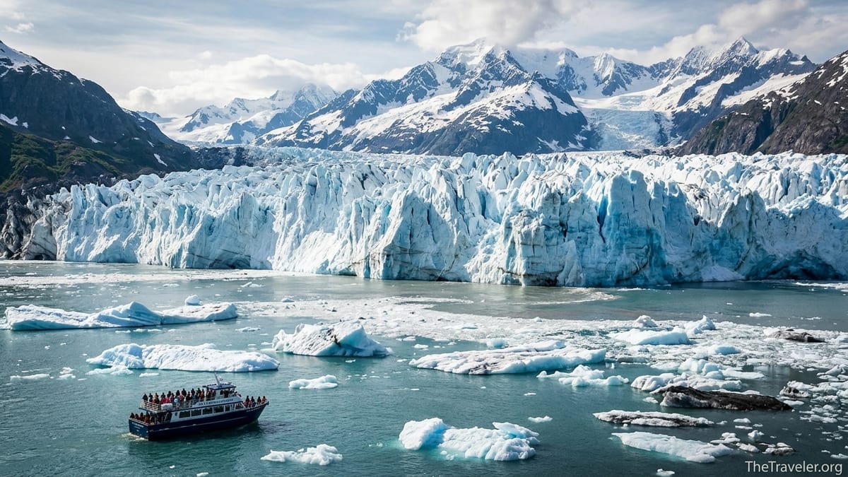
Stand on the deck of a cruise ship in Disenchantment Bay and Hubbard Glacier can look like a giant frozen contradiction. While guides talk about melting ice and climate change, the glacier in front of you is famously advancing, occasionally pushing so far forward that it blocks nearby Russell Fiord. For some visitors this raises an unsettling question: if Hubbard Glacier is growing, does that mean global warming has been exaggerated? The scientific answer is no. Hubbard’s advance is real, remarkable and dramatic, but it is driven by local glacier dynamics and geography, not a reversal of global climate trends.
Get the latest updates straight to your inbox!
Glacier basics: advance, speed, terminus, mass and health
To understand Hubbard Glacier’s unusual behavior, it helps to unpack a few glacier terms that are often blurred together in everyday conversation. When scientists say a glacier is "advancing," they are talking about the position of its terminus, the seaward or downhill edge. If that edge creeps forward over months to years, the glacier is advancing; if it pulls back, the glacier is retreating. This is different from how fast the ice is flowing internally, which can speed up or slow down even while the terminus appears steady.
The terminus position is controlled by a balance between ice arriving from upstream and ice lost at the front through melting and calving. A glacier can advance because more ice is being delivered to the front, because melting and calving at the front have decreased, or both. In tidewater settings such as Yakutat and Disenchantment bays, where many visitors see Hubbard from cruise ships, calving is especially important because huge blocks of ice break off into the sea every day.
Total glacier mass is another story again. A glacier might advance at its front even while it is losing more ice overall than it gains each year. That can happen if the thick, heavily snow-fed upper reaches are temporarily overwhelming losses downstream. Glacier "health" in a climate sense is usually assessed through mass balance: the difference between snow accumulation (mostly in the high-elevation accumulation zone) and all forms of ice loss, including melt, sublimation and iceberg calving. Satellite and field measurements show that global glacier mass balance is strongly negative in recent decades, even though a handful of individual glaciers, like Hubbard, are advancing at their termini.
This distinction matters for climate debates. A traveler watching Hubbard’s towering ice face grind forward toward Gilbert Point could be forgiven for thinking it disproves global warming. But scientists working in the Saint Elias Mountains have long emphasized that a single glacier’s front position cannot stand in for the complex network of measurements that reveal widespread glacier thinning across Alaska and the rest of the world.
Hubbard’s exceptional setting in the Saint Elias Mountains
Hubbard Glacier is exceptional even by Alaskan standards. Stretching more than 120 kilometers from its accumulation basins in the Saint Elias Mountains down to tidewater, it drains an enormous high-altitude snowfield that straddles the Alaska–Yukon border. United States Geological Survey studies describe Hubbard as the largest tidewater glacier in North America by area, with an accumulation zone that sprawls across peaks where storms from the Gulf of Alaska wring out heavy snowfall year after year. ([pubs.usgs.gov](https://pubs.usgs.gov/fs/fs-001-03/?utm_source=openai))
This geography matters. While many coastal glaciers near popular ports like Juneau and Seward tap smaller catchments that top out at modest elevations, Hubbard’s headwaters rise into some of the snowiest terrain on the continent. Moist marine air slams into the Saint Elias range and cools rapidly, dropping snow that can stack tens of meters deep in high basins over time. That snow compacts into ice and begins a long journey seaward, converging from multiple tributary valleys into the broad main trunk visitors see from cruise ships and sightseeing flights out of Yakutat.
Hubbard’s flow path carries that ice through a relatively narrow bedrock valley before it fans out into Disenchantment Bay. There, its tidewater terminus spans roughly 10 kilometers, with ice cliffs that can rise as high as a 30 story building. The front is grounded on a complex underwater landscape, including a submarine terminal moraine near Gilbert Point that helps brace the ice margin. Bathymetric surveys and USGS tidewater glacier reports show that this shoaling at the terminus makes Hubbard’s front more stable than that of calving glaciers that plunge into very deep water right at their faces.
For travelers, this geography shapes the experience on the water. Ships entering Disenchantment Bay must thread a channel west of Gilbert Point, sometimes weaving around large icebergs that have calved recently from the glacier. The very fact that there is a narrow navigable channel instead of wide-open sea is a clue to how far seaward Hubbard’s ice has advanced compared with the positions mapped in early 20th century surveys.
How snowfall, ice transport, melting and calving control advance
A glacier like Hubbard is powered by snowfall in its accumulation zone. Snow that survives the summer melt season is progressively buried, compressed and turned into glacier ice. Gravity then pulls this ice downslope. In the high interior of the Saint Elias Mountains, temperatures remain cold enough that melt is limited for much of the year, so a large fraction of the snowfall is preserved and eventually funneled toward the coast.
As this ice flows downstream, it enters lower and warmer elevations where surface melting increases. On land-terminating glaciers you might see meltwater streams cutting bright blue channels on the ice in late summer. On Hubbard, much of this meltwater eventually drains through the glacier to its base, where it can influence how easily the ice slides over the bed. When the ice reaches the sea, additional processes take over. The submerged part of the terminus is attacked by relatively warm ocean water, which causes submarine melting, while waves and buoyant forces encourage the ice cliff above to crack and calve icebergs.
Hubbard’s long-term advance implies that, over the last century or more, the supply of ice to the front has on average exceeded the combined losses from surface melt, submarine melt and iceberg calving. Detailed measurements of ice thickness, flow speed and front position compiled in glaciological journals show that the lower reaches of Hubbard thickened by tens of meters in the late 20th century and that the glacier increased its total volume over several decades, even as neighboring glaciers thinned.
That still does not mean Hubbard is immune to warming oceans or air temperatures. The rate of submarine melting depends on the temperature and circulation of seawater in Disenchantment Bay. Warmer water could erode the submerged ice more quickly and change calving behavior. In the field, scientists and crew on local tour boats witness this as increased iceberg production and more frequent thunderous collapses along certain parts of the face during warm spells. The crucial point is that for Hubbard, so far, the upstream snow engine and its unique seabed geometry have continued to overwhelm these losses, allowing its front to creep seaward even in a warming world.
Why Hubbard advances: bathymetry, moraine and the tidewater glacier cycle
Hubbard is part of a broader pattern known as the tidewater glacier cycle, a concept developed from decades of research in Alaska and elsewhere. In this cycle, large calving glaciers advance into deep fjords during a "stable" or advancing phase, often helped by the growth of a submarine moraine at their fronts. As they push forward, they bulldoze sediment that drops out of the ice and settles on the seabed, gradually building a shoal. This shoaling can reduce water depth at the ice front, making it less buoyant and less prone to rapid calving.
USGS fact sheets and peer-reviewed studies describe Hubbard as a textbook example of the advancing phase of this cycle. Bathymetric mapping and repeated front-position surveys suggest that for more than a century the glacier has advanced several kilometers, with an average rate on the order of a few tens of meters per year along much of its terminus. In places the thickening of its lower trunk has been measured at more than 80 meters over roughly four decades.
The submarine terminal moraine near Gilbert Point is central to this story. As Hubbard’s front grinds over the seafloor, it shoves sediment forward, building an underwater ramp that helps support the ice edge at shallow depth. That support limits how much of the front can float, and in turn helps hold calving rates in check. This is very different from nearby Columbia Glacier, which retreated rapidly in the late 20th century after its front receded into deeper water, became more buoyant, and began calving icebergs at much higher rates.
It is also important to distinguish Hubbard’s slow, steady advance from a "surge." Surging glaciers undergo short-lived episodes of dramatically increased flow speed, often advancing kilometers in just a few years before thinning and retreating again. Many tributary glaciers feeding Hubbard have shown surging behavior, but the main trunk itself has not. Studies of its motion and calving patterns across the 20th century find a consistent, relatively modest flow speed at the front and no evidence of the abrupt accelerations typical of surges.
When a glacier becomes a dam: Russell Fiord in 1986 and 2002
Hubbard’s advance is not just a concern for glaciologists. It has already reshaped local waterways in dramatic ways that visitors can still see the traces of today. At the southeast corner of Disenchantment Bay, a narrow opening leads into Russell Fiord, a long saltwater arm that extends toward the forested mountains behind Yakutat. The gap between Gilbert Point and the glacier’s eastern front is the only connection between this fiord and the open Gulf of Alaska.
In May 1986 Hubbard’s eastern terminus surged against Gilbert Point strongly enough to pinch off that connection. Landsat imagery and USGS hydrologic reports show that by early summer the glacier and its submarine moraine had created an ice and sediment dam, turning Russell Fiord into a closed basin that scientists named Russell Lake. As meltwater and stream inflows accumulated, the lake’s surface rose roughly 25 meters above sea level over about four months. The water freshened rapidly, threatening marine species in what had been a saltwater ecosystem.
Around midnight on 8 October 1986, moving water finally found a weak point. The ice and sediment dam failed catastrophically, and an estimated billions of cubic meters of water poured back into Disenchantment Bay in roughly a day. This was a classic glacial lake outburst flood, the sort of event that can radically reshape channels and shorelines. In Yakutat, people did not see a towering wall of water arrive in town, but scientists monitoring the event documented strong currents and rapid changes in water level and salinity near the fiord entrance.
The second closure came in 2002. That year, repeated observations by local pilots, cruise lines and researchers showed Hubbard again shoving against Gilbert Point, once more cutting off Russell Fiord. Hydrologists recorded the new Russell Lake rising about 19 meters across roughly ten weeks. This time the closure was shorter and less complete, with some water overtopping or seeping through the moraine. In mid August 2002 the dam gave way and another major flood roared out into Disenchantment Bay, ranked by glacial hazard researchers as one of the largest documented glacial lake outburst floods of recent decades.
For travelers today, these episodes are more than historical curiosities. When you sail past Gilbert Point, you are passing over the rebuilt and reworked submarine moraine that twice helped hold back a growing lake. The narrowness of the channel, the swirling currents and the heavy sediment load in the water are all real-world signs of the ice–sediment interactions that made those closures possible.
Looking ahead cautiously: future closure risks and post 2025 monitoring
Because both 1986 and 2002 closures ended in large outburst floods, scientists and local managers remain understandably cautious about what might happen if Hubbard blocks Russell Fiord again. USGS summaries and Alaska scientific forums have long noted that if a future dam grew high and strong enough, Russell Lake could in theory rise until it spilled southeastward over a low pass into the Situk River drainage. That would transform a celebrated salmon river and world class fly fishing destination near Yakutat, altering water temperatures and sediment loads and potentially impacting both the ecosystem and the local tourism and fishing economy.
At the same time, it is important to avoid overconfident predictions. A 1991 report once projected that Hubbard might permanently close Russell Fiord by around 2000, a forecast that did not come to pass. Since 2002, the glacier has continued its overall advancing trend but with year to year variability in how close its eastern front approaches Gilbert Point. Russell Fiord has remained a marine fiord connected to the Gulf of Alaska, and Yakutat has not experienced the Situk River diversion scenario that earlier studies outlined as a possibility.
On 6 December 2025, a magnitude 7.0 earthquake struck beneath the Saint Elias Mountains near Hubbard Glacier, generating numerous landslides and snow avalanches onto the glacier and nearby slopes. USGS and NASA Earth Observatory reports document that airborne and satellite imagery in the days after the quake revealed streaks of debris across the ice surface and into tributary valleys. However, as of late 2026, public summaries from these agencies focus mainly on the landslides themselves and do not yet report a fundamental shift in Hubbard’s long term advance pattern as a direct result of the earthquake. Monitoring continues through satellite altimetry, optical imagery and occasional on the ground measurements. These tools allow researchers to track subtle changes in flow speed, surface elevation and terminus position year by year. For now, the cautious verdict is that Hubbard remains an advancing tidewater glacier with a history of occasionally damming Russell Fiord and a nonzero chance of doing so again, but the exact timing, style and consequences of any future closure remain uncertain.
Comparing Hubbard to retreating and other advancing Alaska glaciers
Hubbard is striking not only because it advances, but because so many of its Alaskan neighbors are doing the opposite. Glaciological surveys across Alaska show widespread thinning and retreat of mountain and valley glaciers from the Kenai Peninsula and Prince William Sound to Glacier Bay National Park. Visitors who hike to Exit Glacier near Seward or take day boats into Kenai Fjords and College Fjord see prominent signs marking where the ice front stood decades ago, now well upvalley of its current position.
Even in the Yakutat region, Hubbard is an outlier. Scientific compilations of glacier volume change highlight extensive thinning on nearby non-tidewater glaciers whose ablation zones have expanded under warmer summer conditions. These glaciers lack the massive high elevation accumulation areas and stabilizing submarine moraines that help Hubbard resist retreat. A traveler flying from Anchorage to Yakutat on a clear day can look down and see this contrast from the air: many smaller glaciers frayed and pulled back from their Little Ice Age limits, Hubbard’s broad trunk still driving confidently into the sea.
There are, however, a few other advancing tidewater glaciers in Alaska, such as Taku Glacier near Juneau, which advanced for more than a century before recently showing early signs of thinning near its terminus. These glaciers, like Hubbard, appear to occupy a favorable combination of heavy snowfall, efficient ice funneling and supportive basin geometry that lets them buck the broader trend for a time. They are important natural laboratories for understanding how glacier dynamics, sedimentation and fjord depth can either amplify or counteract the climatic signal.
For climate science, the key point is that such exceptions are rare and well studied. Their behavior fits within physical models of tidewater glacier cycles rather than contradicting them. In climate assessments, researchers use regional and global inventories of glacier mass change that average over thousands of glaciers. In those data sets, the losses from retreating glaciers far outweigh the gains from a handful of advancing ones like Hubbard, confirming that overall glacier ice in Alaska and worldwide is shrinking.
Simple mass balance, climate controls and local ocean–geology effects
One way to visualize Hubbard’s situation is to imagine a simple timeline running from the high snowfields of the Saint Elias crest to the calving front in Disenchantment Bay. At the top, the glacier gains mass from snowfall. Moving downslope, it slowly loses mass to surface melt. Near the terminus, it loses additional mass to submarine melting and iceberg calving. The overall mass balance is just inflow minus outflow. If snowfall plus upstream thickening add more ice than melting and calving remove, the glacier can thicken and its front can advance, even in a warming climate.
Climate change acts mainly on the accumulation and melt sides of this diagram. Warmer air temperatures affect how much winter precipitation falls as snow versus rain, and how fast seasonal snow and glacier ice melt in spring and summer. Warmer oceans and changes in coastal circulation influence how quickly fjord water can erode the submerged part of the ice front. In contrast, the shape of the bedrock valley, the presence of a submarine moraine and the rate of sediment delivery are local controls that influence how the glacier responds to those climatic pushes.
If we sorted these influences into a simple table, snowfall patterns, air temperature and large scale ocean warming would sit under a "climate" column, while fjord depth, seabed shape, sedimentation rates, local currents and tectonic uplift would sit under an "oceanographic and geological" column. Hubbard’s advance today reflects a particular combination from both columns: heavy snowfall and cold high elevations on the climate side, plus a supportive moraine and favorable bathymetry on the local side. It is the blend that matters, not any single factor in isolation.
For a traveler comparing Hubbard to a rapidly retreating glacier like Columbia Glacier in Prince William Sound, this framework explains why the two can behave so differently in the same warming regional climate. Columbia retreated quickly once its front retreated off a submarine sill into deep water, losing the stabilizing effect that Hubbard currently enjoys. Hubbard, by contrast, is still in an advancing phase of the tidewater glacier cycle, with its front braced on shallower ground and fed by a particularly robust accumulation area.
Scientific verdict and what Hubbard means for global climate evidence
Taking all of this together, glaciologists see Hubbard Glacier as a dramatic but well understood exception, not as a refutation of global warming. Over more than a century of observation, its main trunk has continued a generally steady advance, thickening in its lower reaches and twice damming Russell Fiord long enough to create a temporary lake before catastrophic outburst floods restored the marine connection. Its behavior fits established models of tidewater glacier dynamics, sediment driven moraine growth and the influence of fjord depth on calving.
At the same time, comprehensive measurements across Alaska and the world show that most glaciers are losing mass and retreating. The extra snowfall and favorable geometry that currently sustain Hubbard’s advance could eventually be outweighed by ongoing regional warming, just as appears to be happening now for some other formerly advancing tidewater glaciers. Nothing in Hubbard’s story overturns the consistent lines of evidence for human driven climate change from thermometers, satellites, sea level records and the widespread retreat of thousands of other glaciers.
For visitors to Yakutat and Disenchantment Bay, that nuance is part of the fascination. Watching Hubbard calve icebergs the size of houses, cruising past the narrow gap at Gilbert Point or flying over Russell Fiord with a local air taxi outfit, you are not seeing climate change disproven. You are seeing the interplay of weather, climate, geology and oceanography compressed into a single spectacular landscape. Understanding why this glacier advances while most others retreat turns a thrilling day trip into a window on how complex and yet how consistent Earth’s changing ice really is.
FAQs: is Hubbard growing, will it block the fiord again and is it surging?
Is Hubbard Glacier actually growing in size? Over several decades of measurements, scientists have found that Hubbard’s lower trunk has thickened and its total ice volume has increased, even as many neighboring glaciers have thinned. That said, detailed, up to date mass balance numbers are limited, and researchers are cautious about declaring that every part of the glacier is gaining mass in the present climate. The safest statement is that Hubbard remains in a relatively thick and advancing state compared with earlier in the 20th century.
Could Hubbard block Russell Fiord again? Yes, future temporary closures are considered plausible. The glacier has already done so twice, in 1986 for roughly four months and in 2002 for on the order of ten weeks, each time leading to the rapid rise of Russell Lake followed by a major outburst flood when the ice and sediment dam failed. Scientists remain alert to the possibility that another advance against Gilbert Point could repeat this pattern, but they are careful not to specify an exact timetable or to assume that the next closure would behave identically to past events.
Is Hubbard Glacier undergoing a surge? No. While some of its tributaries exhibit surge type behavior, studies of the main glacier find no evidence for the short lived, extremely rapid advances that define surging. Instead, Hubbard has shown a comparatively steady advance over more than a century, with seasonal and year to year variations but no classic surge episodes.
What does climate change mean for Hubbard’s future? Climate change is already reshaping glaciers across Alaska through warmer air temperatures, altered snowfall patterns and warming oceans. Hubbard’s exceptional size, high elevation accumulation basins and supportive fjord geometry have so far allowed it to keep advancing at its front. However, glaciologists expect that if regional warming continues, even such robust glaciers may eventually experience reduced accumulation or increased frontal melting that could slow, halt or reverse their advance. That transition has not yet been clearly documented for Hubbard, and scientists avoid declaring permanent outcomes based on current trends alone. For now, Hubbard remains a powerful example of how local conditions can delay, but not cancel, the broader influence of a warming climate on Earth’s ice.