
The trail to Ramsey Cascades, the tallest waterfall accessible by trail in Great Smoky Mountains National Park, looks deceptively gentle at the start. You stroll an old gravel road beside a chattering creek and pass families playing in the water. Yet step by step, root by root, that easy riverside walk transforms into one of the park’s most demanding day hikes. By the time you hear the roar of the 100 foot falls, you have climbed more than 2,000 feet in just four miles and negotiated boulders, slick rock and tight squeezes through old growth forest. This is a trail that keeps getting tougher the higher you climb, and understanding that progression is the key to enjoying it safely.
Get the latest updates straight to your inbox!
Understanding the Ramsey Cascades Trail
Ramsey Cascades sits in the Greenbrier section of Great Smoky Mountains National Park, east of Gatlinburg, Tennessee. The out and back route is about 7.9 to 8 miles round trip, with roughly 2,200 to 2,400 feet of elevation gain depending on the mapping source. The National Park Service describes the trail as relatively challenging, and most local outfitters list it as strenuous. For many visitors who are used to paved overlooks and short nature loops, Ramsey Cascades is often the hardest hike of their Smokies vacation.
On the map, the numbers already hint at why the effort ramps up. A gain of more than 2,000 feet in four miles averages out to 500 to 600 feet per mile, which is comparable to some steep sections on well known climbs like Alum Cave toward Mount Le Conte. In reality, the grade is not evenly distributed. The first 1.5 miles along the old road are forgiving, which lulls people into a false sense of security. The upper half of the hike compresses most of the elevation gain into rugged terrain where you need hands as much as feet.
The payoff is considerable. Ramsey Cascades drops roughly 100 feet in multiple stair steps over huge boulders into a rocky basin where salamanders are commonly spotted. In high flow after a summer thunderstorm, the falls send a low rumble through the forest; in late autumn, when water levels are lower and leaves have dropped, you can clearly see the multi tiered structure of the cascade framed by bare tree limbs. The combination of waterfall, old growth forest and remote atmosphere is what convinces hikers to push through those demanding upper miles.
It is important to check current conditions before you go. In spring 2026, bear activity prompted temporary closures of Ramsey Prong Road and the trail itself on some days, part of a pattern of periodic shutdowns for wildlife issues, storm damage and past multi year rehabilitation work. Ask at Sugarlands Visitor Center the day before you hike, or call the park information line from Gatlinburg, so you are not driving 30 minutes up Greenbrier Road only to find a locked gate.
The Gentle Beginning: Old Road and Riverside Walking
Most people begin the day by driving from downtown Gatlinburg along U.S. 321 and then up Greenbrier Road, which turns from pavement to gravel as you approach the Ramsey Cascades trailhead parking lot. In peak summer, the small lot can fill by mid morning, forcing latecomers to park along the road and add extra walking before they even reach the signboard. Another subtle way the trail gets harder the higher you climb is simply that a crowded start means you may be walking farther and starting later, which compounds fatigue and heat later in the day.
The first mile or so follows the remnants of an old jeep road. Underfoot, you are mostly on compacted dirt and gravel, wide enough for two or three people to walk side by side. Families with young kids often stop here to splash in shallow pools and take photos of small cascades in the Middle Prong of the Little Pigeon River. The grade is steady but mild, similar to walking a long, sloped driveway. On a cool April morning, fit hikers in trail runners and light daypacks often cover this section in 20 to 25 minutes, barely breaking a sweat.
Even in this easy stretch, you are already laying the groundwork for success higher up. Temperatures in Greenbrier can be humid by late May, and it is not unusual to see people starting up at 10 or 11 a.m. with a single half liter bottle from a gas station cooler. Local guides in Gatlinburg typically recommend at least 2 liters of water per person and a small lunch for Ramsey Cascades, because that placid road walk quickly gives way to more demanding terrain where stopping to filter water or sit on a rock becomes part of your day.
About 1.5 miles from the trailhead, the path narrows, the old road fades and wooden footbridges begin to appear. You cross foaming side streams that can run ankle deep after heavy rain. If you arrive the day after a big summer storm, you will see fresh leaves and branches in the water and hear the higher pitch in the river’s roar. These are early hints that higher up, where the trail clings more closely to Ramsey Prong, those same storms can turn roots and rocks into a slick obstacle course.
Where the Work Begins: Roots, Rocks and Rising Grade
Once you leave the old road, the trail’s character changes quickly. The tread becomes a narrow corridor of dirt packed between protruding roots, uneven stones and occasional log steps. Short, flat stretches still appear, but now they are interspersed with uphill bursts where you gain 80 to 100 feet of elevation in just a couple of minutes. For hikers who came from sea level the day before, this is often where breathing becomes noticeably harder.
A real world example: a reasonably fit couple from Atlanta, used to walking three miles on the BeltLine, might reach this point feeling confident. After another mile and several rooty climbs, they find themselves stopping every 10 minutes, hands on hips, to catch their breath. One of them may start to feel their knees complaining as they step up knee high roots. Without trekking poles, they rely heavily on quadriceps and balance. Trail runners and outfitters in Townsend and Gatlinburg often recommend collapsible poles precisely because this midsection of Ramsey combines steeper grade with awkward footing.
The corridor of trees also tightens. Where the lower road felt airy and open, here you weave among hemlock, tulip poplar and maple trunks, with rhododendron encroaching on both sides. In mid June, the forest is fully leafed out, and humidity trapped in the understory can feel stifling by midday. The sunlight that filtered nicely through the canopy at 9 a.m. may now beat down in bright patches, turning dark rock steps into slick, warm surfaces as moisture condenses and evaporates. The cumulative effect is a hike that feels increasingly steep and “sticky” with every switchback.
Trail rehabilitation completed in 2024 improved drainage and added stone steps in some of the worst eroded areas, but the work did not change the basic reality that you are climbing alongside a mountain stream in a rugged cove. New staircases, turnpikes and retaining walls make the trail more sustainable, but they also concentrate the climb into defined steps that some hikers find surprisingly tall. It is not unusual to see people sit down on a rock for a snack at the base of one stone staircase, realizing this is no longer a casual stroll to a waterfall.
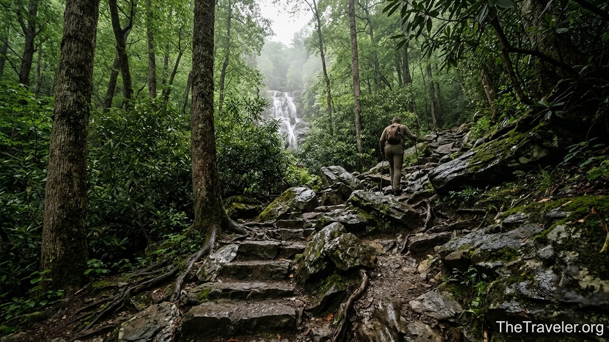
The Final Push: Scrambles, Narrow Ledges and Mental Fatigue
The last mile to Ramsey Cascades is where the trail truly earns its strenuous rating. Here the grade steepens again, the tread narrows and the river noise grows louder. In several places, the path threads between massive boulders with drop offs on one side toward the rushing Ramsey Prong. Roots form natural steps, but they are polished by thousands of boots. After a wet night, these roots and nearby rocks can be as slick as ice, even under a canopy of leaves.
One common scenario involves late starting day hikers who underestimate the time required. The Gatlinburg tourism office advises planning five to seven hours round trip. If you leave the trailhead at noon in October, spend an hour and a half on the climb, and then slow dramatically in the upper mile, you may arrive at the falls close to 3:30 p.m. After a quick set of photos and a snack, you turn around only to realize that descending the same boulders is slower than you expected, especially if there are wet leaves on the rocks. It is entirely possible to be picking your way down these upper sections in the gray light of early evening, long after the families you saw at the lower pools have driven back to Gatlinburg for dinner.
Narrow ledges add a psychological challenge. In at least two spots, the trail traverses sloping rock with a handline of roots or a tree trunk on the uphill side. The drop to the creek below is not sheer cliff, but a tumble over boulders that could easily mean broken bones. Rangers in the Smokies have recorded multiple serious injuries and several fatalities at or near Ramsey Cascades over the years, often involving visitors scrambling off trail on wet rock near the falls. That sobering history is why you will see clear warning signs instructing you not to climb the rocks at the base or sides of the cascade.
By the time you catch your first glimpse of white water through the trees, many hikers feel the wear of 3 to 4 hours of constant attention: watching every foot placement, gauging the next step, negotiating oncoming traffic in tight spots. This mental fatigue is another reason the upper trail feels tougher. A stumble here is more likely because you are tired and eager to be done. When you finally step out into the wide rocky basin below Ramsey Cascades, the sense of release is profound, but so is the realization that you must down climb every root and boulder you just came up.
Why Trail Conditions Keep Evolving
Part of what makes Ramsey Cascades feel tougher every year is that the trail itself continues to evolve. Heavy rain events in the Smokies have become more frequent in recent decades, triggering flash floods that scour creek banks and undercut tread in narrow hollows like Greenbrier. After significant flooding in the early 2020s, parts of the access road and trail were closed for extended repairs, and even now you can see high water lines on boulders and toppled trees along the river. Each major storm shifts rocks, exposes new roots and carves deeper ruts into steeper sections.
Park crews and partner organizations have responded with targeted rehabilitation. Projects completed by the Trails Forever program have added rock staircases, improved drainage and rerouted eroded switchbacks. In practice, this means sections that were once a jumble of loose rock may now be more defined but steeper stone steps. Some hikers perceive this as the trail “getting harder,” even as the work actually makes it safer and more sustainable. If you hiked Ramsey Cascades a decade ago and return today, you may find that your old mental map no longer matches the precise feel of the final climb.
Wildlife management can also complicate access. In April 2026, rangers temporarily closed Ramsey Cascades Trail and Ramsey Prong Road after multiple bear incidents in the area. While such closures are usually short lived, they highlight another way the experience can shift from year to year. On days when the trail is open but recent bear sightings are posted at the trailhead, hikers may feel on edge, especially in the dense, tunnel like sections of rhododendron where visibility is limited. Carrying bear spray where legal and making consistent noise in clustered groups become part of your mental checklist as you climb.
Overlay these factors on a backdrop of rising visitation to the Smokies and you get a trail that often feels busier but no less wild. On a sunny Saturday in October, you might share the lower mile with dozens of people in casual sneakers. Higher up, the numbers thin, but you still queue briefly at narrow crossings where one party must step aside to let another pass. The combination of changing tread, higher traffic and increasingly rugged terrain is what gives Ramsey Cascades its reputation as a trail that intensifies with every step.
Preparing for a Hike That Gets Tougher as You Go
The best way to enjoy Ramsey Cascades is to plan from the outset for a hike that starts as a walk and ends as a true mountain climb. For most people, that begins with an early start. Local guides and lodge owners in Gatlinburg often recommend hitting the trailhead between 7 and 8 a.m., especially in summer, to beat both heat and crowds. Leaving town after an early breakfast means you can return by mid afternoon, even with a leisurely lunch at the falls and plenty of photo stops.
Footwear matters more here than on many other waterfall walks in the park. While you will see some people on the lower road in sandals or canvas sneakers, the upper half of the trail rewards sturdy, grippy soles and ankle support. A midweight hiking shoe with a lugged rubber outsole, like many models sold at outfitters in Gatlinburg and Pigeon Forge, will give you better traction on wet roots than a flat soled running shoe. Adding lightweight trekking poles, which you can rent from some local outdoor shops for the day, can reduce knee strain and improve balance on steep descents.
Water and food are equally critical. A common guideline for this trail is at least two liters of water per person, with more in hot weather, plus a calorie dense lunch and snacks. In practical terms, that might mean a 32 ounce bottle on each side of your daypack plus a sandwich, nuts and a piece of fruit. Because you will be exerting yourself more in the upper miles, many hikers find they eat more than they expected. Having an extra granola bar or energy chews can make the difference between a sluggish, head down trudge back to the car and a relatively strong finish.
Finally, carry a simple safety kit. It does not have to be elaborate, but a headlamp or small flashlight, a basic first aid kit, a light rain jacket and a paper map from a visitor center are worthwhile for a trail like this. Every year, rangers respond to calls from hikers who misjudged sunset or slipped on wet rock on the way down. Being able to see your feet in fading light, bandage a scraped shin or stay warm if an afternoon thunderstorm rolls in can turn a potential emergency into a manageable inconvenience.
At the Falls: Beauty, Risk and Respect
When you arrive at Ramsey Cascades, the scene feels like a natural amphitheater. Water fans out over multiple ledges of dark rock and plunges into a jumbled basin of boulders. In spring, moss glows bright green on shaded stones, and spray coats everything within a few meters of the main chute. In autumn, fallen leaves swirl in eddies at the pool’s edge. It is an irresistible place for photos, picnics and simply standing still after the effort of the climb.
Yet this is also where the risk spikes if you let your guard down. The rocks around the base of the falls are wet year round, and algae can make them slick even in late summer drought. Several fatalities in recent decades have involved visitors climbing up the boulders to get closer to the main drop, only to slip and fall. This history is why the National Park Service explicitly warns hikers not to climb the rocks or attempt to scale the falls. Staying on dry, lower rocks a safe distance from the main plunge and resisting the urge to scramble higher is a simple but vital form of respect for both the place and your own safety.
Practical choices at the falls can also shape how hard the return hike feels. Spending 30 to 45 minutes sitting still, eating lunch and letting your muscles cool can make the first few hundred yards of descent feel stiff and awkward. Some hikers prefer to walk a short loop among the nearby trees, stretch calves and hips, and start back down before they get too chilled, especially on cool shoulder season days. In July and August, on the other hand, the spray and shade can be a welcome respite from the heat; just remember that you still have four miles of careful footwork before you reach your car.
Sound carries oddly in this tight basin. On crowded weekends, you may hear whoops and laughter from groups filtering in behind you, mixing with the constant roar of water. Midweek mornings or winter days can be hauntingly quiet, with only the waterfall and the occasional call of a bird echoing off the rock walls. Choosing your timing not only influences trail difficulty but also the mood at the destination. A quieter visit makes it easier to absorb subtle details, from the pattern of lichen on the boulders to the way mist forms tiny rainbows in shafts of sunlight near midday.
The Takeaway
Ramsey Cascades is not just another Smokies waterfall stroll. It is an 8 mile, high effort day that saves most of its challenge for the upper miles, where grade, footing and exposure to slick rock all intensify. The trail’s progression from easy road to rugged scramble can catch visitors off guard, particularly those who fixate on the first mile’s gentleness and underestimate how much climbing and concentration still lie ahead.
Yet for hikers who respect that progression, plan an early start, carry appropriate gear and remain cautious at the falls, Ramsey Cascades is one of the park’s most rewarding outings. The chance to walk through old growth forest, trace a mountain stream from gentle riffles to thundering cascade and stand in a remote, moss fringed basin is a Smokies experience of the highest order. Understanding that the trail keeps getting tougher the higher you climb is less a warning than an invitation: prepare well, pace yourself and let the challenge sharpen your appreciation of every step.
FAQ
Q1. How long does it take to hike the Ramsey Cascades Trail?
Most hikers should plan on 5 to 7 hours round trip, including short breaks and time at the falls. Faster, very fit parties may finish closer to 4.5 hours, but slower groups or those taking many photo stops can easily spend a full day on the trail.
Q2. How difficult is the trail compared with other Smokies hikes?
The Ramsey Cascades Trail is widely considered strenuous because of its 2,000 plus feet of elevation gain, rocky footing and steep upper mile. If you find hikes like Alum Cave or Chimney Tops challenging, expect Ramsey to feel similar or slightly tougher, especially near the top.
Q3. Is the entire trail suitable for children?
The lower mile on the old road and along the river can be suitable for many children with supervision, and families often play near the lower pools. The upper half, with its narrow tread, steep drop offs and slick rocks, is better suited to experienced older kids and teens who are surefooted and understand trail safety.
Q4. What is the best time of year to hike to Ramsey Cascades?
Late spring through late fall is generally the most popular window. April and May offer high water and wildflowers, summer brings lush greenery but more heat and humidity, and October combines colorful foliage with cooler air. Winter can be beautiful but may include ice, snow and dangerous conditions on the upper rocks.
Q5. Do I need a parking pass or permit?
Great Smoky Mountains National Park now requires a parking tag for vehicles parked longer than 15 minutes at most trailheads, including Greenbrier. You can purchase a daily, weekly or annual tag in nearby towns or at select machines in the park. No special backcountry permit is required for a day hike to Ramsey Cascades.
Q6. Are pets allowed on the Ramsey Cascades Trail?
No. Dogs and other pets are not allowed on the Ramsey Cascades Trail, in line with broader Smokies regulations that only permit pets on a few short, designated trails and in campgrounds and roadways.
Q7. What gear should I bring for this hike?
At minimum, bring sturdy hiking shoes, 2 liters or more of water per person, snacks or lunch, a light rain jacket, a small first aid kit and a headlamp. Trekking poles are strongly recommended for the steep, rocky sections, and many hikers also carry bear spray where allowed by park regulations.
Q8. Is the trail crowded?
The lower mile can be busy on weekends and holidays, especially in summer and during peak fall color. Traffic thins in the upper miles because of the difficulty, but you should still expect to encounter other hikers and occasional bottlenecks at narrow crossings on popular days. Early morning starts usually mean fewer people.
Q9. Can I swim at the base of Ramsey Cascades?
The pool at the base is cold, rocky and directly below powerful falling water, and the rocks around it are extremely slick. While some visitors wade in shallow areas nearby in warm weather, rangers strongly discourage swimming or climbing on rocks close to the main cascade because of the history of serious accidents.
Q10. How do recent trail closures and bear activity affect my plans?
Temporary closures for trail work, storm damage or bear activity are not uncommon around Ramsey Cascades. Before your visit, check current conditions through park information channels or at a visitor center in Gatlinburg. If the trail or access road is closed, choose an alternative nearby hike such as Porters Creek Trail in Greenbrier until conditions improve.