
The first time you drop off Cedar Mesa and follow Kane Gulch toward Junction Ruin, the miles feel longer than they look on the map. Sand slows your stride, dryfalls force detours, and the canyon walls close in. Yet when you round the last bend and the multi-level stone dwellings of this Ancestral Puebloan site finally appear in the alcove ahead, every aching step suddenly feels worth it. This is a hike that is as much about the journey as the destination, and finding Junction Ruin after a long day on the trail has a way of reordering what you consider a “good” adventure.
Get the latest updates straight to your inbox!
Where Junction Ruin Sits In The Desert Southwest
Junction Ruin is tucked into the confluence of Kane Gulch and Grand Gulch on Cedar Mesa in southeastern Utah, part of the Bears Ears region. This is classic Four Corners canyon country: a high plateau cut by deep sandstone gashes, pinyon and juniper on the rims, cottonwoods and willows down low in the washes. Kane Gulch is one of the main entry points into Grand Gulch, and Junction Ruin sits roughly eight miles round trip from the Kane Gulch Ranger Station trailhead, making it a full but manageable day hike for strong walkers.
The site itself is an Ancestral Puebloan cliff dwelling complex built into the canyon wall on several levels, with dozens of structures visible from the opposite bank. Archaeologists date occupation here to the Basketmaker II period with later use into the Pueblo period, before the area was largely abandoned in the thirteenth century. Today, Junction Ruin is one of the more frequently visited sites in Grand Gulch, yet compared with places like Mesa Verde or Wupatki, it still feels remote and intimate, reached only by a long walk instead of a parking lot boardwalk.
Reaching the trailhead is part of the experience. From the small town of Blanding or Bluff, you drive south on US 191 or west on US 163, then climb Utah State Route 95 onto Cedar Mesa before turning onto UT 261. A signed turnoff leads to the Kane Gulch Ranger Station, where a paved parking lot, composting toilets, and information boards mark one of the few obvious human footprints on the mesa top. In high season, rangers are usually on hand in the morning to answer questions and check permits, but once you step onto the trail, the modern world falls away quickly.
That sense of stepping out of time is what gives this hike its particular magic. Junction Ruin is not simply “a ruin” waiting at the end of a track; it is the focal point of a landscape where water, stone, and human ingenuity intersect. The long approach through an ever-deepening canyon prepares you to meet it on its own terms, not as a quick roadside attraction but as the living remnant of a community that once relied on this same fragile desert.
Preparing For A Long Day On The Kane Gulch Trail
Even though the route to Junction Ruin is often described as moderate, it is an eight-mile round trip in desert terrain, with limited shade for much of the day. Temperatures on Cedar Mesa in late spring and early autumn can reach the high 70s to mid-80s Fahrenheit in the afternoon, and the reflected heat off the sandstone makes it feel hotter in the canyon bottom. Most experienced hikers carry at least three liters of water per person for this day hike, plus electrolytes; more in the hotter months.
The Kane Gulch trail starts with a gradual descent from the mesa rim, then drops more steeply into the wash. Underfoot you can expect a mix of firm dirt singletrack, patches of sand that sap your energy, and sections of broken rock that require careful foot placement. Lightweight hiking boots or sturdy trail runners with good tread are appropriate. In spring, after snowmelt or heavy storms, there can be muddy stretches and small pools in the wash; quick-drying pants and socks make the inevitable splashes less of an issue.
Essential gear here is simple but non-negotiable. A brimmed hat, sunglasses, and high-SPF sunscreen are mandatory, as there are long exposed sections with little shelter. Trekking poles help on the steeper steps and during the climb back out in the afternoon when your legs are tired. Many hikers wear a 20 to 30 liter daypack to carry water, snacks, an insulating layer for the often-cool morning start, and a light rain shell in monsoon season when fast-building thunderstorms can move across Cedar Mesa in the afternoon.
Permits are required to hike in Grand Gulch, with separate systems for day use and overnight trips. Day-use permits for the Kane Gulch to Junction Ruin hike are typically obtained at the ranger station, with a daily quota that can fill during peak spring and fall seasons. Regulations emphasize Leave No Trace ethics and strict protection of cultural sites, which means you must stay on established trails, avoid touching walls or rock art, and never enter rooms or kivas. For visitors used to more hands-on exploration, this restraint is an adjustment, but it is central to why Junction Ruin still looks and feels as intact as it does today.
The Long Walk Down Kane Gulch
From the trailhead, the first mile or so feels deceptively easy as the path winds through pinyon-juniper forest and sagebrush. The air is cool, and the canyon below remains hidden. Soon you begin to lose elevation more quickly, the soil underfoot gives way to slickrock steps, and glimpses of sandstone walls open through the trees. Many hikers begin this descent around 8 a.m. in late spring, catching the soft morning light and cooler temperatures before the sun climbs high.
Once you drop fully into Kane Gulch, the character of the hike changes. The trail merges with the sandy wash in places, and your pace slows. Cottonwoods and willows trace the intermittent flow of water, and depending on the season you may see pools lingering in bends of the canyon. After a wet winter, these pools can be home to chorus frogs and dragonflies; after a dry spell, the wash can be bone-dry and powdery. Either way, the high vertical walls amplify the silence, broken only by your footsteps and the occasional call of a raven circling above.
About halfway to the junction, side alcoves and overhangs begin to appear in the canyon walls. It is here that many hikers first feel the tug of anticipation, scanning every shadow for the first sign of masonry. You may spot small granaries or eroded walls high above, but these are often subtle and far from the trail. It is tempting to leave the route and scramble closer, yet it is essential to resist: the crusted desert soils are easily damaged, and unstable slopes have led to accidents in the past. The best vantage points are almost always from the main trail or the opposite canyon wall.
Physically, this middle stretch of the hike can feel monotonous. The canyon meanders, and progress is measured not in sweeping vistas but in the slow, rhythmic crunch of sand and the way the light moves across the walls. For some, this is where doubts creep in: Is the ruin really worth it? Did we start too late? It is precisely this honest grind, however, that sets up the emotional payoff. When you finally arrive at Junction Ruin, the reward is richer because your body remembers every turn that led you there.
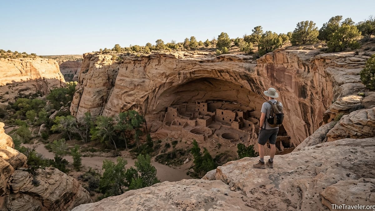
The First Glimpse Of Junction Ruin
As you approach the confluence where Kane Gulch meets Grand Gulch, the canyon opens slightly and the sound of your footsteps spreads into a broader space. The trail bends, and then, almost without warning, the main alcove housing Junction Ruin comes into view on the right-hand wall. Stone rooms, some with intact walls and doorways, cluster in tiers across the alcove floor and up the vertical faces above. Even from a distance, the geometry is striking: rectangular rooms, round kiva depressions, and neat rows of masonry set against the soft curves of eroded sandstone.
Most hikers instinctively stop in their tracks at this first sightline. After miles of subtle hints and partial features, here is an unmistakable village preserved in place. You can see multiple levels of construction, with lower rooms built on ledges and higher structures tucked against the roof of the alcove. Smoke-blackened ceilings hint at ancient fires; small openings suggest storage rooms where corn and squash were once kept safe from rodents and damp. The scale is intimate rather than monumental, yet its presence in this remote canyon feels profound.
A well-used social trail leads to a designated viewing area opposite the main ruin, where you can sit on flat sandstone and study the architecture without approaching the walls. From here, details emerge the longer you look: faint handprints in the plaster, the curve of a kiva outline on the alcove floor, stones carefully chinked with smaller rocks and mortar to create smooth surfaces. With a pair of binoculars or a zoom lens, you may spot even more subtle elements like small granaries higher up the cliff, nearly camouflaged against the rock.
The emotional shift in this moment is hard to overstate. Hours of heat, sand, and doubt fall away, replaced by a quiet awe that is less about ticking off a destination and more about recognizing that you are a brief visitor in a place where people lived, worked, and raised families for centuries. It is here, looking across at the ruin with tired legs and dust on your boots, that the journey feels fully justified. The hike has slowed you down enough that you can actually receive what the place has to offer.
Spending Time Respectfully At The Ruin
Once you arrive, it can be tempting to rush in, snap a few photos, and turn back. The richest experiences at Junction Ruin, however, come from lingering. Many hikers budget at least 45 minutes to an hour at the site, finding a shaded rock to sit on as they drink water, eat a snack, and let their eyes trace the lines of the village. Midday can be hot, but the alcove creates its own microclimate, with cooler air pooling near the back and light reflecting off the canyon floor in shifting patterns.
This is also the moment to lean into cultural respect. Modern Pueblo communities in the Southwest view these places not as abandoned relics but as part of a living continuum of their history. While hiking guides may still use the word “ruin,” many archeologists and tribal members now prefer terms like “ancestral sites” or simply the place name. Practically, this means staying off walls, never entering rooms or kivas, and absolutely refraining from touching rock art or artifacts. If you notice pottery shards on the ground, the correct response is to observe them, photograph them if you wish, and leave them exactly where they lie.
From a traveler’s perspective, this restraint often deepens the experience. Instead of climbing around for the best selfie, you find yourself studying the village from a respectful distance, trying to imagine daily life here: children running along ledges, corn grinding in manos and metates, smoke drifting out of roof openings. That act of imagination is part of what makes the journey feel worth it. You are engaging not just with stones but with the lives that animated them.
Photography at Junction Ruin can be especially rewarding in the softer light of late morning or early afternoon when shadows reveal the texture of masonry without harsh contrast. A mid-range zoom lens in the 70 to 200 millimeter range allows you to capture details from the approved viewing area without encroaching on fragile surfaces. Tripods are generally discouraged near cultural sites because of crowding and impact on the ground, so most photographers work handheld, increasing ISO as needed to maintain fast shutter speeds.
Why The Journey Feels More Rewarding Than A Roadside Ruin
There are many remarkable Ancestral Puebloan sites across the Southwest that you can access with minimal effort. At Mesa Verde in Colorado, for example, you can drive to cliff dwelling overlooks and join ranger-led tours with short walks. At places like Mule Canyon Ruin near Utah State Route 95, you can step from your car onto a paved path that circles reconstructed rooms and a kiva. These sites are important, accessible, and often a good introduction for travelers with limited mobility or tight schedules.
Yet the subjective feeling of arriving at Junction Ruin after hiking all day is different. The physical investment changes your relationship to the place. Your legs remember the climb out of the wash, your skin remembers the heat, and your mind has had hours to shed the noise of daily life. When the site finally appears, it does so against the backdrop of your own effort. That personal cost, while modest compared with multi-day backpacking routes, transforms the visit from a quick stop into a small pilgrimage.
This dynamic plays out in other long-approach sites too. Travelers who hike to remote cliff dwellings in Arizona’s Sierra Ancha or backpack into canyons in Bears Ears often describe a similar sense of earned wonder. The specifics differ, but the pattern is consistent: a demanding approach, moments of doubt, gradual immersion in a powerful landscape, and then, finally, the revelation of an ancient dwelling or rock art panel that feels intimately connected to the land around it. Junction Ruin fits squarely into this pattern, accessible enough for a fit day hiker yet remote enough to feel genuinely wild.
Psychologically, effort tends to increase perceived value. When you have carried every liter of water on your back, navigated dryfalls, and paced your energy over the day, you are more likely to slow down and savor what you came for. In a travel world full of drive-up viewpoints and crowded overlooks, that slowness may be the rarest luxury of all. Junction Ruin is not just a place you see. It is a place you arrive at, in every sense of the word.
Planning Your Visit: Seasons, Safety, And Local Logistics
The best times to hike to Junction Ruin are generally spring and fall, roughly April to early June and late September to October, when daytime temperatures on Cedar Mesa are more moderate and water pockets in the canyon are more likely. Summer brings often intense heat that can push into the 90s Fahrenheit in exposed sections, along with monsoon thunderstorms that can produce flash flooding in canyon systems like Kane and Grand Gulch. Winter can offer solitude and crisp air but also icy patches on the descent and shorter daylight hours.
Realistically, most visitors base themselves in nearby towns like Blanding, Bluff, or Mexican Hat, where you can find simple motels, small groceries, and gas stations. One common pattern is to stay in Blanding the night before, drive roughly an hour to the Kane Gulch Ranger Station in the morning, complete the hike, then either return to town or continue on to other Cedar Mesa trailheads or scenic viewpoints along UT 261, such as Muley Point. Fuel up before leaving town, as there are no services at the trailhead.
Safety in this landscape comes down to foresight. Flash flooding, though not a daily occurrence, is a real hazard during stormy periods. Checking weather forecasts for the broader Bears Ears and Cedar Mesa region before your hike is essential, and if storms are predicted, it is wise to adjust your plans. Many experienced hikers start even earlier than usual on days with potential afternoon build-up, aiming to be back on the rim by early afternoon.
Navigation on the Kane Gulch to Junction Ruin route is generally straightforward but still benefits from some preparation. The primary trail is usually well-defined, but flood events can scour sections, and side paths can be confusing in the wash. Carrying a topographic map of Cedar Mesa, a GPS app with offline maps, or a dedicated GPS unit gives extra confidence, especially if you are new to canyon country. Always sign in and out at the trailhead register, not only for your own safety but also to help managers understand traffic levels and plan for resource protection.
The Takeaway
Finding Junction Ruin after a long hike is about more than ticking off a destination on a map. It is about allowing the desert to work on you mile by mile, stripping away distractions until the only things that matter are water, shade, and the next bend in the canyon. When the ruin finally appears, tucked into its sandstone alcove at the junction of two canyons, the feeling is not just “I made it” but “I am finally moving at the speed of this place.”
For travelers used to quick scenic stops, this can be a recalibration. The hike from Kane Gulch to Junction Ruin asks you to commit a full day, carry your needs on your back, and navigate an environment that is beautiful but unforgiving if underestimated. In return, it offers one of the most rewarding combinations of natural and cultural experience in the Southwest: a living landscape, a beautifully preserved ancestral site, and the quiet satisfaction of having earned your view.
If you are planning a trip to Cedar Mesa or the broader Bears Ears region, set aside the time and energy for this hike. Start early, carry more water than you think you will need, and be prepared to move slowly and respectfully through a canyon that has cradled human stories for more than a thousand years. By the time you climb back to the rim in the late afternoon, legs tired and memory card full, you may find that the journey to Junction Ruin has reshaped not only your sense of distance, but your understanding of what makes travel truly meaningful.
FAQ
Q1. Where exactly is Junction Ruin located?
Junction Ruin sits at the confluence of Kane Gulch and Grand Gulch on Cedar Mesa in southeastern Utah, reached from the Kane Gulch Ranger Station off Utah State Route 261.
Q2. How long is the hike to Junction Ruin and how difficult is it?
The out-and-back hike is roughly eight miles round trip. It is considered moderately strenuous due to sandy sections, some rocky steps, and the climb back to the rim.
Q3. Do I need a permit to hike to Junction Ruin?
Yes. Day-use permits are required for hikes in Grand Gulch. These are typically obtained at the Kane Gulch Ranger Station, where quotas help protect sensitive cultural resources.
Q4. When is the best time of year to do this hike?
Spring and fall are usually best, roughly April to early June and late September to October, when temperatures are milder and daylight is ample without peak summer heat.
Q5. How much water should I carry for the hike?
Most hikers carry at least three liters of water per person for this eight-mile desert hike, more in hotter conditions, since reliable drinking water sources cannot be guaranteed in the canyon.
Q6. Can I explore inside the rooms at Junction Ruin?
No. Visitors must stay off walls and out of rooms and kivas. The site is viewed from designated areas to protect fragile masonry and respect its cultural significance.
Q7. Is the trail suitable for beginners or kids?
Fit beginners and older children with hiking experience can complete the hike, provided you pace the day carefully, start early, and are prepared for desert heat and variable footing.
Q8. Are there camping options near the trailhead?
There are primitive camping areas on Cedar Mesa and established campgrounds farther away, but no developed campground at the Kane Gulch Ranger Station itself, so most visitors stay in nearby towns.
Q9. What should I pack besides water and snacks?
Pack sun protection, sturdy footwear, a brimmed hat, extra layers, a basic first-aid kit, navigation tools, and plenty of high-energy food. Trekking poles are very helpful on the descent and climb out.
Q10. Why does reaching Junction Ruin feel especially rewarding?
The combination of a substantial hike, the silence of an isolated canyon, and the sudden appearance of an ancestral village creates a powerful sense of earned discovery that many roadside sites cannot match.