
I did not plan to get lost in Urho Kekkonen National Park. Like most visitors to Finnish Lapland, I imagined tidy loops from trailhead to trailhead, an orderly sequence of viewpoints, and sauna sessions that arrived exactly on schedule. Instead, a missed turn in the fells near Saariselkä sent me wandering off the marked route, out of my comfort zone, and into the most memorable part of my trip. The vastness that had intimidated me on the map became, step by step, the reason I fell in love with this wilderness.
Get the latest updates straight to your inbox!
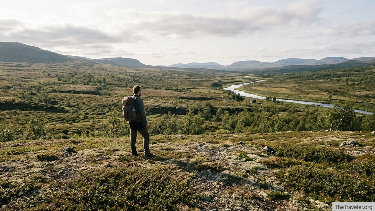
Meeting the Vastness of Urho Kekkonen for the First Time
I arrived in Saariselkä, the northern gateway to Urho Kekkonen National Park, on a late August afternoon. The village itself feels like a compact resort hub, with a supermarket, a couple of gear shops renting trekking poles and snowshoes in winter, and cafés serving pulla and strong coffee. Just beyond the last cabins, however, the landscape opens into bare fells, dwarf birch, and a horizon so wide it made my usual city sense of distance feel almost useless.
At the visitor center in Saariselkä, staff explained that Urho Kekkonen National Park sprawls across more than 2,500 square kilometers of Lapland wilderness along the Russian border. They pointed out that while there are roughly 200 kilometers of marked trails in the Saariselkä–Kiilopää area, only about half of those lie inside the national park itself. Beyond this web of waymarked day routes, a lattice of unmarked paths and reindeer tracks crosses valleys and fells. The message was clear: navigation here is your responsibility.
I bought a 1:50,000 paper map covering Saariselkä, Kiilopää, and the central fells, then double-checked that the offline map on my phone was downloaded and working. In the gear shop next door, a local guide advised me to think in terms of terrain features rather than just colored posts. “In fog or snow you might not see the markers,” he said. “But you will always have a ridge, a river, or a valley to orient by.” At the time, this sounded like theoretical advice. Two days later, it became very practical.
The Wrong Turn That Changed the Entire Hike
My original plan was modest: a two-day out-and-back from Saariselkä to the Rautulampi area, using the well-known “Out to the Fell” trails that form scenic day loops. The route starts innocently enough, climbing gently out of the village, ski runs on one side and low forest on the other. Red and blue trail markers show summer and winter routes, and for the first hour it is almost impossible to imagine getting lost.
Above the tree line, the terrain flattened. Low fells rolled into each other, a patchwork of rust-colored heath and lingering snowfields on north-facing slopes. I paused for lunch near a wooden shelter, trading a few words with a Finnish family hiking to a nearby lean-to for the night. They were planning to return to their cabin and a pre-booked hotel sauna in Saariselkä. I had a simpler goal: reach the open wilderness hut near Rautulampi, spend a quiet night there, and follow the same route back.
Instead, somewhere after a junction where a narrower path branched toward Kiilopää, I followed a faint trail that was not on my GPS track. It looked trodden enough, and there was no sign explicitly telling me not to go that way. For a while, everything seemed fine. The weather stayed clear, and the path gently paralleled a stream. Then the posts disappeared. After another twenty minutes I realized I had not seen a single waymark, and the “path” was little more than flattened heather and old reindeer prints.
This is the moment when “getting lost” begins. My phone still showed me within the park, and I was not in any immediate danger, but the comfort of a painted line and numbered trail was gone. I had two choices: backtrack until I rejoined the known route, or accept that I had drifted into the park’s unmarked interior and adjust my plan accordingly.
Turning Disorientation into a Different Kind of Journey
Standing on that nameless slope, I remembered what the guide in Saariselkä had said about reading the landscape. To my right, a high ridge curved like a lazy question mark. To my left, the stream cut deeper into a shallow valley, its line eventually bending toward the southeast. On my map, I could see a similar pair of features forming a corridor that led, not back to Rautulampi, but toward the larger Luirojärvi area, a classic multi-day destination deep in the park with a cluster of wilderness huts and a small lakeside sauna.
Luirojärvi had been in my “someday” folder, a place I associated with long-haul through hikers who started at Saariselkä and finished near the Russian border. Now it appeared in front of me as a realistic option, if I was willing to accept an unscheduled detour and a very different kind of trip. I checked the time. It was still early afternoon, visibility was good, and the weather forecast from the morning promised stable conditions for at least 24 hours. The decision quietly made itself. I turned my back on the idea of retracing steps and began angling toward that distant chain of hills.
Urho Kekkonen is often described as “wilderness-like” even where human traces exist, and it is in this middle zone that the park feels most alive. I walked for hours without seeing another person, but I passed reindeer silently grazing on lichen, heard the brittle call of a ptarmigan, and crossed tiny wooden bridges clearly built by hands that cared about keeping boots dry. There was no official route number, no trail name printed on Instagram checklists. Just the steady rhythm of placing one foot in front of the other, keeping the ridge to my right and the deepening valley to my left.
As evening approached, I reached a crossroads of sorts: a faint but more clearly worn path crept alongside the stream, and in the distance I could make out the straight lines of a timber building near the water. The map confirmed what I hoped: a wilderness hut, one of dozens scattered across the park like punctuation marks in a long sentence. My accidental detour had just turned into an unplanned hut-to-hut experience.
Discovering the World of Lapland Wilderness Huts
Staying in a Finnish wilderness hut for the first time feels like stepping into a shared story that hikers have been adding to for decades. The hut I reached that evening was a typical open hut: a simple log structure with bunks, a central table, a wood-burning stove, and a guestbook swollen with notes in Finnish, German, French, and English. Many entries described similar experiences: wrong turns, changed plans, storms waited out by the fire, friendships made over shared coffee.
Open huts in Urho Kekkonen are free to use for one or two nights, maintained by Metsähallitus, the Finnish state body that manages national parks. Some nearby buildings operate as reservable huts, where you pay a modest nightly fee for a guaranteed bunk. Prices vary a little by hut and season, but as of recent years a spot in a reservable hut might cost on the order of 15 to 30 euros per person, which feels remarkably generous considering the remoteness. At popular nodes like Rautulampi, one building may house both an open and a reservable section, providing flexibility depending on how firm your plans are.
What impressed me most was not the cost, but the culture surrounding these huts. When I arrived, there were already two hikers inside: a Finnish couple on a weeklong traverse toward Nuortti, another multi-day route along a canyon-like river in the park’s eastern reaches. They made space on the bench, handed me a steaming cup of instant soup, and immediately included me in the evening’s quiet routine: fetching water from the river, splitting kindling, sweeping sand and needles from the floor so the hut would be clean for the next arrivals.
We compared maps and routes. When I confessed that I had ended up here by accident after missing a signposted junction, they just nodded. “Urho Kekkonen will do that,” one of them said. “But being a little lost is good here, as long as you have time, a map, and respect for the weather.” It struck me that getting lost in this context was less about panic and more about letting go of strict itineraries. The hut system, and the tradition of leaving firewood and kindling ready for the next person, made that surrender feel safe rather than reckless.
Rewriting the Itinerary: From Day Hike to Mini Expedition
Over the next two days, my improvised route took me deeper into the park’s interior, linking huts and campsites that I had previously dismissed as “too far” for my schedule. Instead of returning directly to Saariselkä, I angled my path toward the more distant fell country, where rounded summits and broad plateaus replace the smaller knuckles of the tourist-side hills. In one valley, willow scrub brushed my knees and the ground squished underfoot, forcing me to slow down and pick each step carefully. In another, a dry, stony slope allowed me to see for kilometers in every direction, the sense of isolation magnified by late-summer silence.
This was a different style of travel from the neatly marked loop I had originally chosen. I stopped thinking in terms of “kilometers remaining” to the next viewpoint and started paying attention to how the terrain changed hour by hour. When I reached Luirojärvi on the second evening, the lake lay almost perfectly still, reflecting a ring of low fells and a sky streaked with high, thin cloud. Several wilderness huts clustered near the shore, along with a small public sauna that hikers can book by leaving a few euros in a fee box, a uniquely Finnish luxury at the heart of such emptiness.
That evening, after a cold dip in the lake and a turn in the dim, wood-scented sauna, I realized how far I had traveled from my original mental map of the trip. I had left behind the schedule that fit neatly into train timetables and hotel bookings, and stepped instead into a looser rhythm more in tune with daylight, weather, and the distance between huts. It felt less like a holiday and more like a gentle apprenticeship in Lapland’s way of moving through land.
Practically speaking, this kind of shift requires flexibility. I used my satellite messaging device to send a short note to my guesthouse in Saariselkä, explaining that I would be returning a day later than planned. Many accommodations in Lapland are used to this; the receptionist simply replied that it was no problem so long as I paid the extra night on arrival. In a place where winter storms can cancel buses and summer floods can slow river crossings, “plans subject to change” seems to be part of everyday life.
How to Get Comfortably “Lost” in Urho Kekkonen
My unplanned detour ended well because I had a solid base of preparation underneath the spontaneity. Urho Kekkonen might be full of gentle, rolling hills rather than jagged peaks, but its size and remoteness demand respect. If you want to leave the clearly marked day trails near Saariselkä or Kiilopää and lean into a bit of creative route-finding, there are a few practical strategies that make that kind of “good lostness” possible.
First, carry a proper topographic map and know how to read it. The national park visitor center and outdoor shops in Saariselkä and Ivalo sell maps that show both marked routes and common unmarked paths, along with hut locations and major river crossings. Combine this paper backup with an offline navigation app on your phone or GPS device. Signals can be patchy once you head deeper into the fells, so download the relevant tiles in advance rather than relying only on a live data connection.
Second, understand the hut system before you set off. Note the approximate spacing between open wilderness huts and reservable huts along your intended direction of travel. On many of the classic interior routes, huts are positioned a comfortable day’s walk apart for a moderately fit hiker, but distances can stretch quickly once you leave the main corridors. In summer and autumn, carrying a lightweight tent or bivy setup gives you extra flexibility if a hut is full or you decide to stop short of your original goal.
Finally, build weather and margin into your schedule. Lapland’s conditions can turn quickly, especially from September onward and in winter, when whiteouts make navigation much more serious. If you are planning a multi-day crossing rather than day hikes, give yourself at least one spare day that can absorb a delay due to fog, heavy rain, or simply tired legs. Being able to wait out bad weather in a hut instead of pushing on into poor visibility is exactly what turns potential crisis into a memorable story instead.
Moments You Only Find When the Plan Falls Apart
Looking back on my time in Urho Kekkonen, the scenes that stand out most clearly are those that never appeared in any brochure. Early on my second “lost” day, while contouring around a low fell, I startled a small herd of reindeer that had been feeding in a hollow. Instead of bolting immediately, they trotted to a nearby ridge and paused in a loose line, watching me with the same cautious curiosity I felt for them. No other human figures broke the horizon. If I had been racing to make a pre-booked shuttle at a certain hour, I would have barely noticed them. Instead, I stood quietly and watched until they drifted away.
Later that same day, as clouds thickened and wind picked up, I decided to stop earlier than planned at a smaller hut tucked beside a narrow river. Only two bunks and a table fit inside. A handwritten note on the wall, left by a visitor a few years ago, read simply: “We arrived tired, thinking of quitting. But this hut made us stay one more night in the park.” There was something deeply reassuring about joining that anonymous chorus of people who had also revised their plans, slowed down, or simply admitted that the original schedule no longer fit the reality outside.
Even the small inconveniences of being off-plan became part of the trip’s texture. I rationed the more interesting trail snacks once I realized I would be out an extra day, leaving the luxury items for morale on the final long slog back toward Saariselkä. I accepted that my return bus would have to be rebooked at a slightly higher fare, a minor cost for the chance to see the interior lakes and fells that had not fit into my first draft of the itinerary. These were not disasters, just negotiations with reality, the kind of give-and-take that real travel often demands but guidebooks rarely emphasize.
Above all, that unexpected stretch in the wilderness reset my sense of scale. On a map, the distance from Saariselkä to the deeper huts near the park’s center is only a few centimeters. On the ground, each rise and valley, each marsh crossing and river ford, elongated those centimeters into days. Getting lost in such a place did not mean spinning in circles; it meant discovering that the land itself, rather than my timetable, would decide how long the journey should take.
The Takeaway
Urho Kekkonen National Park is often described in superlatives: one of Finland’s largest protected areas, a flagship of Arctic wilderness, a place where boreal forest gives way to tundra. Those facts are impressive, but they are not what I remember most clearly. What stayed with me was quieter: the sound of wind over a nameless fell, the glow of a hut stove shared with strangers, the honest tiredness of a day spent following landforms rather than trail signs.
Losing the trail, for a little while, forced me to let go of the idea that good travel is tidy and efficient. In this park, being slightly off course, as long as you are prepared, can reveal a slower, more reciprocal way of moving through nature. The unplanned hut nights, the changed exit point, the extra day added to the schedule: these became the spine of my story, not the detour from it.
If you come to Urho Kekkonen expecting a neat package of viewpoints and attractions, you might be frustrated by the park’s scale and the way its trails thin out the farther you go. But if you allow for a little uncertainty, if you carry the right tools and leave space in your plans, you might find that getting “lost” out there is exactly what you needed. In my case, the moment the red posts disappeared from view was the moment my trip truly began.
FAQ
Q1. Is it safe to get off the marked trails in Urho Kekkonen National Park?
It can be safe for experienced, well-prepared hikers who carry proper maps, navigation tools, and extra supplies, and who respect the rapidly changing Lapland weather.
Q2. Do I need to book wilderness huts in advance?
Open wilderness huts generally cannot be reserved and work on a first-come basis, while many reservable huts require advance booking, especially in busy seasons.
Q3. How far apart are the huts in the park?
On popular interior routes, huts are often a comfortable day’s walk apart for fit hikers, but distances vary and you should always confirm spacing on current maps before setting out.
Q4. Can beginners enjoy Urho Kekkonen without getting lost?
Yes, beginners can stick to well-marked day trails around Saariselkä and Kiilopää, staying close to services and clearly signposted routes while still experiencing fell landscapes.
Q5. What time of year is best for a first visit?
Late summer and early autumn typically offer snow-free trails, long daylight, and fewer insects than midsummer, making them ideal for a first multi-day hike in the park.
Q6. Do I need to carry a tent if I plan to use huts?
Carrying a lightweight tent or bivy is strongly recommended as a backup in case huts are full, your pace is slower than expected, or weather forces an early stop.
Q7. Is mobile phone coverage reliable inside the park?
Coverage is reasonably good near Saariselkä and Kiilopää but becomes patchy deeper inside the park, so you should not rely solely on a phone for navigation or communication.
Q8. How should I prepare for weather changes?
Pack layered clothing, waterproofs, warm gloves and hat even in summer, and always build an extra day into your schedule in case bad weather makes hiking unsafe or unpleasant.
Q9. Can I hike alone, or should I join a guided group?
Confident, well-equipped hikers often go solo, but guided trips from local operators in Saariselkä or Kiilopää are a good option if you lack navigation experience or winter skills.
Q10. What makes getting “lost” here different from getting lost elsewhere?
In Urho Kekkonen, a culture of wilderness huts, good maps, and generally low visitor density means that an unplanned detour can often become a rewarding part of the journey, provided you are prepared.