
Whiteoak Canyon in Shenandoah National Park is one of Virginia’s classic waterfall hikes, a tumbling series of cascades that draws everyone from first-time visitors to seasoned Mid-Atlantic hikers. Its popularity, however, means the Whiteoak Canyon Trail is also a place where a lot of people get caught out by crowds, terrain, and changeable mountain weather. Understanding the biggest mistakes others make on this trail can help you turn a potentially stressful day into a safe, memorable hike to some of the park’s most beautiful falls.
Get the latest updates straight to your inbox!
Underestimating the Trail’s Difficulty and Elevation
On paper, Whiteoak Canyon looks straightforward. The National Park Service describes a 4.6-mile round-trip hike from the upper trailhead on Skyline Drive to Upper Whiteoak Falls, with about 1,040 feet of elevation gain. That sounds manageable to many visitors who have previously handled shorter urban hikes or flat rail-trails. The mistake is assuming those numbers translate into an easy stroll. The grade in Whiteoak Canyon is steady, often rocky, and can feel relentless on the return climb if you start at the boundary and hike uphill at the end of the day.
Hikers frequently comment that they felt fine on the way down to the lower or middle falls, only to find the hike back up took almost twice as long and pushed their fitness limits. For example, a family who parks at the boundary lot near Syria, Virginia and follows the trail up past several of the six major waterfalls can gain more than 1,500 feet if they turn it into a longer out-and-back toward Skyline Drive. For someone used to neighborhood walks, that is a major effort, especially in summer humidity.
A related mistake is not matching the route to the group’s ability. The trail can be done in several ways: a shorter out-and-back to Lower Whiteoak Falls from the boundary, the classic 4.6-mile upper-falls hike from Skyline Drive, or a demanding Whiteoak Canyon and Cedar Run loop that can stretch to 7 to 8.5 miles with steep, rocky sections and creek crossings. Visitors who see only the word “waterfalls” in a blog or social media post sometimes launch into the full loop late in the day and end up hiking out in the dark or exhausted, particularly if they are carrying little more than a small bottle of water.
The best approach is to choose an itinerary that fits the least experienced hiker in your group, then add time padding. If you typically hike 4 miles with 500 to 800 feet of elevation on local trails, expect Whiteoak Canyon to feel harder due to roots, rocks, and the constant up or down. Starting early, building in generous breaks at viewpoints, and being willing to turn around at a particular waterfall rather than “finishing the whole thing” will make the day more enjoyable and safer.
Arriving Late and Losing the Parking Game
Another major mistake on the Whiteoak Canyon Trail is underestimating just how popular it is, especially on spring and fall weekends and in the peak of summer. There are two primary access points: the upper Whiteoak Canyon parking area on Skyline Drive near mile 42.6, and the boundary parking near the end of Route 600/Weakley Hollow Road close to Syria. Both lots can fill by mid-morning on busy days, particularly Saturdays in October leaf season and hot July afternoons when hikers are eager to reach the swimming holes.
When the upper Skyline Drive lot fills, rangers may encourage visitors to try other nearby hikes or return later. At the boundary, the official lot is supplemented in practice by a patchwork of private fields and driveways where local landowners sometimes charge a flat fee, often around 10 to 20 dollars cash, to park for the day or overnight. Hikers who arrive at 11 a.m. from Washington, D.C., expecting to roll straight onto the trail, may find the free National Park Service lot already full and end up circling narrow country roads, eventually paying a landowner on Weakley Hollow Road or adding extra walking distance from farther down the road.
Planning around this means thinking like a local. If you are coming from the D.C. suburbs, aim to leave early enough to reach either the Skyline Drive lot or the boundary parking by 8:30 or 9 a.m., especially on weekends from May through October. In practice, this usually translates to a 6:30 or 7 a.m. departure from Northern Virginia. Traveling midweek or in winter will give you more flexibility, but even then, mid-day start times can mean you are hiking in the warmest or slickest conditions.
Visitors also commonly misunderstand the difference between the park entrance fee and any boundary parking fees. Paying to park in a private field near the boundary does not replace the Shenandoah National Park entrance fee, which most visitors pay at a Skyline Drive entrance station or purchase online as a digital pass. If you plan to hike solely from the boundary without driving Skyline Drive, factor that entrance fee into your trip budget and keep a digital or printed copy of your pass handy in case a ranger checks.
Choosing the Wrong Direction and Underplanning the Route
Whiteoak Canyon can be hiked from the top down or from the bottom up, and each direction affects how your day feels. A common mistake is starting from Skyline Drive without realizing that while the walk to the falls is largely downhill, the return is a sustained uphill climb at the end of your hike. For tired legs and kids who have already played for an hour at the waterfall, that last long climb back to the car can turn into a slog.
Descending from Skyline Drive does have advantages, such as cooler morning air at higher elevation and less initial strain on the cardiovascular system. However, hikers who know they or their companions struggle more with climbing should consider starting from the boundary lot so that the ascent comes first, when everyone is fresh. In practice, that can mean parking off Route 600, following the trail along the river as it climbs naturally past pools and cascades, and turning around at an agreed landmark, such as one of the larger middle falls, giving you a downhill return to the car.
Another frequent planning error is attempting the full Whiteoak Canyon and Cedar Run loop on a whim. This loop links two drainages using a fire road section and is beloved by strong hikers, but it includes steep rocky descents, several creek crossings, and a cumulative elevation gain that can feel punishing to those not used to mountain hiking. Online descriptions often mention “natural waterslides” and “swimming holes” on Cedar Run, which can tempt casual visitors into assuming the loop is a playful water hike. In reality, rains can swell the streams, making crossings slippery, and the rocky sections demand careful foot placement. If you have not done a similar length hike with over 2,000 feet of elevation change recently, consider saving the loop for a future trip.
The final route-planning mistake is not carrying a real map. While phone apps like AllTrails or popular hiking blogs provide helpful overviews, cell reception in Shenandoah is spotty. A printed trail map from a park visitor center or a Shenandoah-specific topographic map from the park bookstore or an outdoor retailer is still the most reliable tool for understanding junctions with the Old Rag Fire Road, side trails, and bail-out options if weather turns or someone in your group is struggling.
Ignoring Water, Weather, and Seasonal Hazards
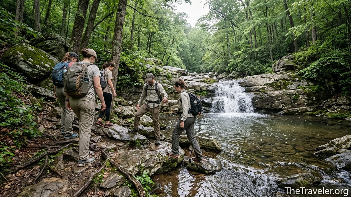
Because Whiteoak Canyon is centered on a rushing mountain stream, people often assume they can treat it as a casual, cool-down hike. The reality is that weather and water conditions in the canyon change quickly and can make the trail significantly more hazardous than visitors expect. After heavy rain, the river swells, obscuring rocks that serve as stepping stones across smaller tributaries and adding power to the main falls. In these conditions, attempting to cross fast-moving water to reach a particular pool or to shortcut along the stream bank can lead to slips, sprains, or worse.
Even under normal flows, the wet rocks near the popular swimming holes are polished and extremely slick. A recurring mistake is stepping onto dark, algae-coated rock in trail runners or sandals without enough grip. It only takes one misstep to fall hard on your tailbone or wrist. Rangers in Shenandoah periodically respond to injuries in the Whiteoak Canyon area that require carry-outs along narrow, rocky stretches of trail, turning a simple day hike into a complex rescue operation that can close sections of the trail for hours.
Seasonal factors compound these risks. Spring brings snowmelt and heavy rains that can turn the path into a muddy ribbon, hiding roots and making every downhill more treacherous. Summer heat and humidity increase the risk of heat exhaustion, especially as hikers climb back out of the canyon in the afternoon sun. Ticks are present from late spring into fall, and poison ivy can grow along trail edges where people pull aside to let others pass. In winter, the canyon can be magical, with ice formations on the falls, but sections of the trail become packed with snow or coated in invisible black ice, particularly in shaded switchbacks. Hikers arriving in sneakers without microspikes or trekking poles often find themselves sliding and grabbing at tree trunks for balance.
Preparation means checking the park’s current conditions the day before your trip and again the morning you leave. Look for alerts mentioning trail closures, high-water warnings, or ice. Pack based on the worst reasonable conditions, not only the forecast at your home. That may involve bringing a lightweight rain jacket, a warm midlayer even in shoulder seasons, sun protection, and a complete change of socks in case your feet get soaked at a crossing. Most importantly, carry far more water than you think you need. A typical adult should plan on at least 2 liters for a moderate hike to the upper falls in summer, more if you attempt longer routes or are prone to dehydration.
Overconfidence Around Swimming Holes and Waterfalls
The pools and cascades of Whiteoak Canyon are famous in the Mid-Atlantic hiking community for swimming and wading. Photos on social media show people lounging in turquoise pools or sliding down smooth rock into deep basins. These images can make the area seem like a natural waterpark. One of the biggest mistakes visitors make is treating it exactly that way, forgetting they are in a wild, unmanaged mountain stream where water depth, current strength, and rock stability change from week to week.
Jumping from cliffs or high rocks into the pools is especially risky. Floods rearrange boulders and deposit logs in unseen places. A spot that was 10 feet deep last August may be only 4 feet deep the following June because gravel has accumulated. There have been incidents across Appalachian waterfall hikes where visitors have severely injured their spines or legs after assuming a pool was deep or clear enough for high jumps. Even low rock slides can catch people off guard if they enter feet-first and hit a submerged ledge or get pulled toward the outflow of the pool faster than expected.
Alcohol and poor footwear compound the danger. It is not uncommon, especially on hot Saturdays, to see hikers carrying small coolers or stopping to drink at the first large pool. Combining alcohol with slick rock and swift water is a recipe for accidents, and it also slows your reaction time on the steep climb back to the car. Similarly, wearing flip-flops or unsecured water sandals in the pools leads to lost footwear and barefoot scrambles over sharp, jagged rock. A better approach is to wear sturdy hiking shoes or trail runners on the walk in, then change into secure water shoes with good tread if you plan to wade, keeping your main footwear dry in a backpack.
Respecting the water also means being mindful of children and non-swimmers. The pools nearest the trail can look calm but may have deeper drop-offs near the outflow or sections where the current narrows between rocks. If you visit with kids, choose shallow, slow-moving stretches of water for play and keep a firm rule about staying far back from the lip of any waterfall or fast cascade. Make sure everyone in your group understands that the safest way to enjoy Whiteoak Canyon is from solid footing, not from the edge of a slick rock shelf overlooking a drop.
Overlooking Crowd Dynamics and Trail Etiquette
Because Whiteoak Canyon is one of Shenandoah’s marquee waterfall hikes, it attracts a mix of experienced backpackers and casual day trippers, as well as large organized groups. On peak weekends, it is normal to encounter hiking clubs from D.C., scout troops, and college groups from Virginia and Maryland colleges. Hikers who are used to quiet backcountry trails sometimes underestimate how much the crowd dynamic changes the experience and, if handled poorly, the safety of the route.
One recurring mistake is failing to build extra time into your day for bottlenecks. Narrow sections of trail, creek crossings on step stones, and the best photo spots near the larger falls can all create queues. It is common to wait several minutes while people pose for group photos at overlooks or carefully shuffle across wet rocks. If you plan your hike assuming a constant 2 to 2.5 miles per hour pace without accounting for these pauses, you may find your return time creeping later and later, cutting into daylight.
Crowds also magnify the impact of poor trail etiquette. Cutting switchbacks to pass slower groups, walking side by side on narrow stretches, or playing loud music from portable Bluetooth speakers can frustrate other visitors and damage the trail. In areas where the soil is already eroding, repeated shortcutting can deepen ruts and increase maintenance needs. Dogs that are off leash or poorly controlled in tight spots can tangle with other pets or push past people near steep drop-offs. Shenandoah requires that dogs be on a physical leash no longer than six feet, and Whiteoak Canyon is no exception to that rule.
The solution is simple but often ignored: treat the trail as a shared, limited resource. Step aside to let faster uphill hikers pass, keep your group tight when others are trying to overtake you, and keep noise levels low enough that you can hear approaching hikers and the natural sounds of the canyon. If you arrive to a busy pool, consider walking a short distance upstream or downstream to find a quieter spot rather than crowding onto a single rock shelf. That mindset will not only improve your own experience but also reduce the stress on vegetation and the trail corridor.
Showing Up Unprepared With Gear, Food, and Logistics
Perhaps the most universal mistake on the Whiteoak Canyon Trail is treating it like a brief roadside stop rather than a mountain hike. Visitors regularly start up the trail with a single small plastic water bottle, no real food, and whatever shoes they happened to be wearing on the drive. That casual approach collides quickly with the reality of a multi-hour outing that involves steady climbing, rocky footing, and exposure to sun and rain.
Shenandoah is not a gear-heavy destination, but a few basics go a long way. Sturdy footwear is essential, whether that is a pair of broken-in hiking boots or athletic trail runners with good grip. A simple daypack large enough to carry at least 2 liters of water per person, some calorie-dense snacks like nuts or energy bars, and an emergency layer such as a light fleece or wind shell can turn an unexpected delay into a mere inconvenience instead of a potential problem. Add a basic first-aid kit with bandages, blister treatment, and any personal medications, and you are considerably better equipped than the average visitor.
Logistical preparation matters too. Cell service drops out quickly as you leave nearby towns like Luray or Sperryville, and in the canyon itself reception is patchy at best. You should download offline maps to your phone before leaving home and take a photo of any posted trailhead map in the parking lot. Check your fuel level in advance; gas stations are sparse near the park’s middle section, and relying on a single station in a town like Syria late in the day can be risky if hours are limited. Even small items like bringing a few dollars in cash for potential private parking at the boundary or keeping a dry bag handy for electronics during sudden storms can significantly smooth the experience.
Finally, many visitors fail to build in time to enjoy the area around the trail. The farmland and orchards in the valleys below the park, as well as nearby stops along Skyline Drive, offer worthwhile detours. Rushing in for a late-morning hike and racing back out to beat traffic shortchanges both the trail and the surrounding region. Planning a full day that includes an early hike, a relaxed stop at a roadside overlook, or a meal in a nearby town will leave you with better memories than trying to squeeze Whiteoak Canyon into a half-day slot between other commitments.
The Takeaway
Whiteoak Canyon is rightly considered one of Shenandoah National Park’s signature hikes, a place where cascading falls, deep forest, and Appalachian geology come together in a narrow, dramatic gorge. The factors that make it so memorable, however, also make it unforgiving if you show up unprepared, underestimate the terrain, or treat the canyon like a theme park instead of a wild landscape. Most of the biggest mistakes visitors make are entirely avoidable with a bit of extra planning.
If you match the route to your fitness, arrive early enough to secure parking, respect the power of water and weather, bring appropriate gear and supplies, and practice thoughtful trail etiquette, you will experience the best of Whiteoak Canyon rather than its common pitfalls. The waterfalls will still be just as impressive, the pools just as cooling, but your day will feel like an intentional adventure instead of a series of surprises. In a park with hundreds of miles of trails, that kind of preparation is what turns a single hike into the highlight of a Shenandoah trip rather than a cautionary tale.
FAQ
Q1. How long does the Whiteoak Canyon hike take for most visitors?
Most day hikers spend between 3 and 5 hours on the trail, depending on route, fitness, and how much time they devote to breaks and swimming at the falls.
Q2. Is Whiteoak Canyon suitable for young children or beginners?
The lower sections from the boundary can work for active kids and beginners, but adults should be ready for uneven, rocky terrain and a noticeable uphill on the return.
Q3. Do I need a special permit to hike Whiteoak Canyon?
You do not need a separate hiking permit for a day visit, but you must have a valid Shenandoah National Park entrance pass, even if you start from the boundary parking.
Q4. Are dogs allowed on the Whiteoak Canyon Trail?
Yes, dogs are allowed but must be on a physical leash no longer than six feet at all times, and owners should be prepared to help them over rocks and keep them safe near water.
Q5. Which parking area is better, Skyline Drive or the boundary lot near Syria?
Skyline Drive offers cooler temperatures and views on the drive, while the boundary lot near Syria provides quicker access from some directions and a more gradual introduction to the canyon.
Q6. Can I swim or jump in the pools below the waterfalls?
Many visitors wade or swim in calmer pools, but conditions vary, and jumping from rocks or cliffs is dangerous due to hidden obstacles and changing water depths.
Q7. What is the best season to hike Whiteoak Canyon?
Late spring and fall are popular for comfortable temperatures and strong flows, though the trail can be hiked year-round with extra care for heat in summer and ice in winter.
Q8. How early should I arrive to find parking on busy weekends?
On peak weekends from late spring through fall, aim to arrive at either the Skyline Drive lot or the boundary parking by about 8:30 or 9 a.m. to improve your chances.
Q9. Is the Whiteoak Canyon and Cedar Run loop too hard for casual hikers?
For most casual hikers, the full loop is a strenuous outing with significant elevation change and rocky sections, so it is best reserved for those with recent mountain-hiking experience.
Q10. What safety gear should I bring specifically for this trail?
Sturdy shoes with good traction, at least 2 liters of water, snacks, a light rain jacket, a basic first-aid kit, and a paper or downloaded map are the key essentials for a safe hike.